The Rock, Tyrone: Difference between revisions
Jump to navigation
Jump to search
No edit summary |
No edit summary |
||
| Line 27: | Line 27: | ||
==References== | ==References== | ||
{{Reflist}} | {{Reflist}} | ||
{{DEFAULTSORT:Rock Tyrone}} | |||
Latest revision as of 18:54, 21 November 2022
| Rock | |
| Tyrone | |
|---|---|
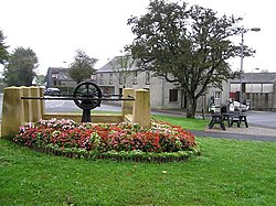
 Disused water pump in The Rock | |
| Location | |
| Grid reference: | H753721 |
| Location: | 54°35’31"N, 6°50’6"W |
| Data | |
| Local Government | |
The Rock is a small village in eastern Tyrone, approximately 5 miles south-west of Cookstown. The village and surrounding area is located mainly within the parish of Desertcreat.
The village name was recorded originally as Baile na Carraige ('Village of rock').[1] A stone quarry later operated in the late 19th and early 20th centuries. A Mass rock exists in Tullyodonnell, half a mile from the village.
Sport
- Gaelic Athletics: Rock St. Patrick's GAC
See also
| ("Wikimedia Commons" has material about The Rock, Tyrone) |
