Turgis Green: Difference between revisions
Redirected page to Stratfield Turgis |
No edit summary |
||
| Line 1: | Line 1: | ||
{{Infobox town | |||
|name=Turgis Green | |||
|county=Hampshire | |||
|picture=Turgis Green, Hants - geograph.org.uk - 445.jpg | |||
|picture caption= | |||
|os grid ref=SU695592 | |||
|latitude=51.3276 | |||
|longitude=-1.0022 | |||
|population= | |||
|post town=Hook | |||
|postcode=RG27 | |||
|dialling code=01256 | |||
|LG district=Basingstoke and Deane | |||
|constituency=Basingstoke | |||
|website= | |||
}} | |||
'''Turgis Green''' is a small hamlet in [[Hampshire]], between [[Hartley Wespall]] and [[Stratfield Turgis]]. It stands by on the northern section of the busy A33 road, which splits it north to south. | |||
==History== | |||
The hamlet is named for the Turgis family that owned land locally in the thirteenth century. Turgis Green was inclosed in 1866 as a result of the General Inclosure Act.<ref>{{VCH|4|Parishes: Stratfield Turgis|pp=63-65}}</ref> | |||
Late in the eighteenth century it was proposed to dig a cut, a canal branch, from the [[Basingstoke Canal]] to Turgis Green but the proposal never came to fruition.<ref>{{cite web |url=http://www.hants.gov.uk/rh/row/maps/1724.pdf |title=The History of the Basingstoke Canal |year=1973 |accessdate=1 January 2011}}</ref> | |||
==Sport and leisure== | |||
The hamlet includes a cricket pitch, home of the Stratfield Turgis & Hartley Wespall Cricket Club, and small children's playground. | |||
==Church== | |||
The Chuch of St Mary the Blessed Virgin (Church of England) stands about a mile from the hamlet and close to [[Hartley Wespall]]. | |||
==Outside links== | |||
*[http://www.stratfieldturgis.org.uk Stratfield Turgis Parish Meeting] | |||
*[http://www.stratfieldturgiscc.co.uk/ Stratfield Turgis & Hartley Wespall Cricket Club] | |||
*[http://www.basingstoke-canal.org.uk/history/bashist4.htm#4/3 The History of the Basingstoke Canal] | |||
*{{NHLE|1339496|Church of St Mary The Blessed Virgin|grade=I}} | |||
==References== | |||
{{reflist}} | |||
Latest revision as of 19:37, 2 November 2022
| Turgis Green | |
| Hampshire | |
|---|---|

| |
| Location | |
| Grid reference: | SU695592 |
| Location: | 51°19’39"N, 1°0’8"W |
| Data | |
| Post town: | Hook |
| Postcode: | RG27 |
| Dialling code: | 01256 |
| Local Government | |
| Council: | Basingstoke and Deane |
| Parliamentary constituency: |
Basingstoke |
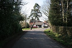
Turgis Green is a small hamlet in Hampshire, between Hartley Wespall and Stratfield Turgis. It stands by on the northern section of the busy A33 road, which splits it north to south.
History
The hamlet is named for the Turgis family that owned land locally in the thirteenth century. Turgis Green was inclosed in 1866 as a result of the General Inclosure Act.[1]
Late in the eighteenth century it was proposed to dig a cut, a canal branch, from the Basingstoke Canal to Turgis Green but the proposal never came to fruition.[2]
Sport and leisure
The hamlet includes a cricket pitch, home of the Stratfield Turgis & Hartley Wespall Cricket Club, and small children's playground.
Church
The Chuch of St Mary the Blessed Virgin (Church of England) stands about a mile from the hamlet and close to Hartley Wespall.
Outside links
- Stratfield Turgis Parish Meeting
- Stratfield Turgis & Hartley Wespall Cricket Club
- The History of the Basingstoke Canal
- National Heritage List 1339496: Church of St Mary The Blessed Virgin (Grade I listing)
References
- ↑ A History of the County of Hampshire - Volume 4 pp 63-65: Parishes: Stratfield Turgis (Victoria County History)
- ↑ "The History of the Basingstoke Canal". 1973. http://www.hants.gov.uk/rh/row/maps/1724.pdf. Retrieved 1 January 2011.