Froxfield, Bedfordshire: Difference between revisions
Jump to navigation
Jump to search
Created page with "{{Infobox town |name=Froxfield |county=Bedfordshire |picture=GOC Woburn 046 Froxfield House and number 9, Froxfield, Eversholt (23143221136).jpg |picture caption= |os grid ref..." |
No edit summary |
||
| Line 5: | Line 5: | ||
|picture caption= | |picture caption= | ||
|os grid ref=SP971333 | |os grid ref=SP971333 | ||
|latitude=51. | |latitude=51.990423348 | ||
|longitude=-0. | |longitude=-0.586 | ||
|population= | |population= | ||
|post town= | |post town= | ||
Latest revision as of 13:07, 9 October 2022
| Froxfield | |
| Bedfordshire | |
|---|---|

| |
| Location | |
| Grid reference: | SP971333 |
| Location: | 51°59’26"N, -0°35’10"W |
| Data | |
| Postcode: | MK17 |
| Local Government | |
| Council: | Central Bedfordshire |
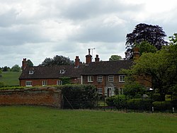
Froxfield is a hamlet in Bedfordshire, at the eastern edge of and indeed indenting, Woburn Park, the parkland of the Duke of Bedford's seat at Woburn Abbey. A local road crosses the park from here to Woburn village.
Woburn Abbey is half a mile south-west of the hamlet, and its safari park half a mile north-west.