Difference between revisions of "Haughton, Nottinghamshire"
From Wikishire
(Created page with "{{Infobox town |name=Haughton |county=Nottinghamshire |picture=Mind the bend - geograph.org.uk - 1068207.jpg |picture caption= |os grid ref=SK680727 |latitude=53.24697 |longit...") |
(→See also) |
||
| Line 15: | Line 15: | ||
The hamlet is about one mile south-west of [[Bothamsall]] (where the population is included for census purposes) and two and a half miles north of [[New Ollerton]]. | The hamlet is about one mile south-west of [[Bothamsall]] (where the population is included for census purposes) and two and a half miles north of [[New Ollerton]]. | ||
| − | |||
| − | |||
| − | |||
==Outside links== | ==Outside links== | ||
Latest revision as of 21:31, 6 October 2021
| Haughton | |
| Nottinghamshire | |
|---|---|

| |
| Location | |
| Grid reference: | SK680727 |
| Location: | 53°14’49"N, 0°58’57"W |
| Data | |
| Post town: | Retforrd |
| Postcode: | DN22 |
| Local Government | |
| Council: | Bassetlaw |
| Parliamentary constituency: |
Newark |
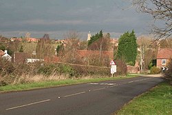
Haughton is a tiny hamlet in the north-east of Nottinghamshire. It stands on the south bank of the River Maun where it is bridged to carry the B6387. A railway line crosses the river here too.
The hamlet is about one mile south-west of Bothamsall (where the population is included for census purposes) and two and a half miles north of New Ollerton.
Outside links
| ("Wikimedia Commons" has material about Haughton, Nottinghamshire) |
- Notts History:
- Haughton in Joseph Rodgers, The Scenery of Sherwood Forest with an Account of some Eminent People there, (1908
- Haughton in Cornelius Brown, A History of Nottinghamshire, 1896
- Haughton in Thoroton's History of Nottinghamshire: republished with large additions by John Throsby, vol III, p359-361, 1790.