Ibstock: Difference between revisions
Created page with "{{Infobox town |name=Ibstock |county=Leicestershire |picture=Ibstock - geograph.org.uk - 60854.jpg |picture caption=St Denys Church, Ibstock |os grid ref=SK4010 |latitude=52.6..." |
|||
| Line 53: | Line 53: | ||
==Sources and further reading== | ==Sources and further reading== | ||
*{{cite book |last=Curtis |first=John |year=1831 |title=A Topographical History of the County of Leicester |publisher=W. Hextall |location=Ashby-de-la-Zouch |pages=80–81}} | *{{cite book |last=Curtis |first=John |year=1831 |title=A Topographical History of the County of Leicester |publisher=W. Hextall |location=Ashby-de-la-Zouch |pages=80–81}} | ||
*{{Cite book |last1=Hoskins |first1=W.G. (ed.) |authorlink1=William George Hoskins |last2=McKinley |first2=R.A. |series=[[Victoria County History]] |title=A History of the County of | *{{Cite book |last1=Hoskins |first1=W.G. (ed.) |authorlink1=William George Hoskins |last2=McKinley |first2=R.A. |series=[[Victoria County History]] |title=A History of the County of Leicester, Volume 2 |year=1951 |publisher=|location=|pages=5–7}} | ||
*{{cite book |editor1-last=Lewis |editor1-first=Samuel | *{{cite book |editor1-last=Lewis |editor1-first=Samuel |title=A Topographical Dictionary of England |edition=Seventh |origyear=1848 |year=1931 |publisher=Samuel Lewis |location=London |pages=600–603}} | ||
*{{cite book |last=Pevsner |first=Nikolaus |authorlink=Nikolaus Pevsner |series=[[Pevsner Architectural Guides#Buildings of England|The Buildings of England]] |title=Leicestershire and Rutland |year=1960 |publisher=Penguin Books |location=Harmondsworth |page=125}} | *{{cite book |last=Pevsner |first=Nikolaus |authorlink=Nikolaus Pevsner |series=[[Pevsner Architectural Guides#Buildings of England|The Buildings of England]] |title=Leicestershire and Rutland |year=1960 |publisher=Penguin Books |location=Harmondsworth |page=125}} | ||
Latest revision as of 18:26, 27 September 2021
| Ibstock | |
| Leicestershire | |
|---|---|
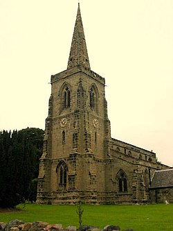
 St Denys Church, Ibstock | |
| Location | |
| Grid reference: | SK4010 |
| Location: | 52°41’13"N, 1°24’4"W |
| Data | |
| Population: | 5,760 (2001) |
| Post town: | Ibstock |
| Postcode: | LE67 |
| Dialling code: | 01530 |
| Local Government | |
| Council: | North West Leicestershire |
| Parliamentary constituency: |
North West Leicestershire |
| Website: | Ibstock Parish Council |
Ibstock is a village in Leicestershire about two and a half miles south of Coalville. The village is on the A447 road Between Coalville and Hinckley.
The name 'Ibstock' could be a derivative of Ibestoche meaning "The Farm of Ibba", which is an Old English personal name also found in other place-names.
Manor
The Domesday Book of 1086 records Ibstock as a hamlet with six ploughlands.
The parish along with a grange held by the Cistercian Garendon Abbey, has a long early association with the Burtons of Bourton-on-Dunsmore in Warwickshire. Early in the 17th century Sir William Stafford of Blatherwick in Northamptonshire owned the manor of Ibstock.
Parish church
The Church of England parish church of St Denys was built entirely in the early 14th century.[1] It is a Decorated Gothic building with a west tower and recessed spire.[1] The nave has two aisles; the north with conventional octagonal piers but the south with less usual hexagonal ones.[1]
The rectory is Georgian and has a porch with four Tuscan columns.[1]
William Laud, later Archbishop of Canterbury, author of the Laudian reforms which were a trigger to the Civil War, held the living here 1617–26. At the outbreak of the Civil War in 1642, John Lufton, then Rector of Ibstock, was accused in the House of Commons of interrupting the execution of the militia ordinance. His living was sequestrated by the County Committee in August 1646.
The parish of Ibstock formerly included the dependent chapelries of Donington le Heath and Hugglescote but the increase of population led to the establishment of a separate ecclesiastical parish in the 19th century.
Economic and social history
Ralph Josselin, the noted clerical diarist and incumbent of a parish in Essex, briefly stayed in Ibstock during the Civil War. On 17 September 1645 he marched from Leicester with the parliamentary army and quartered at Ibstock, noting that it had been "Laud's living, and now Dr Lovedyn a great Cavailier" and that although his diet was "very good" his lodgings were "indifferent". Josselin was alarmed to discover on his return the next day that a man had been killed just outside his lodgings near where he had stood closely a while before "not knowing of the pardue [sic] in the ditch".[2]
In 1774 the township was enclosed and in 1792 a free school for fifty poor children of the parish was founded. The 1801 Census gives a total population of 763, in 152 families, two thirds engaged in agriculture, the rest in trade and manufacturing. By 1811 the population had increased to 836.
Ibstock is within the Leicestershire coalfield and was one a coal mining community.
In the 19th century a branch of the Ashby and Nuneaton Joint Railway was built through the area and Heather & Ibstock railway station was opened to serve the village. Passenger services ended in 1931, with the line through to Coalville East closing completely in 1964, before the publication of Beeching's report "Reshaping of British Railways.[3] The station master's house on Station Road survives.
Outside links
| ("Wikimedia Commons" has material about Ibstock) |
References
Sources and further reading
- Curtis, John (1831). A Topographical History of the County of Leicester. Ashby-de-la-Zouch: W. Hextall. pp. 80–81.
- Hoskins, W.G. (ed.); McKinley, R.A. (1951). A History of the County of Leicester, Volume 2. Victoria County History. pp. 5–7.
- Lewis, Samuel, ed (1931) [1848]. A Topographical Dictionary of England (Seventh ed.). London: Samuel Lewis. pp. 600–603.
- Pevsner, Nikolaus (1960). Leicestershire and Rutland. The Buildings of England. Harmondsworth: Penguin Books. p. 125.
