Template:FP-Merrick: Difference between revisions
Jump to navigation
Jump to search
No edit summary |
No edit summary |
||
| Line 4: | Line 4: | ||
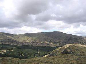
|text='''The Merrick''' is a mountain in [[Kirkcudbrightshire]] - the highest point in that county and indeed the highest mountain in the Southern Uplands. It is part of the Range of the Awful Hand. | |text='''The Merrick''' is a mountain in [[Kirkcudbrightshire]] - the highest point in that county and indeed the highest mountain in the Southern Uplands. It is part of the Range of the Awful Hand. | ||
An interesting feature on the mountain is the presence of several large partly buried granite boulders at about 2,400 feet on the broad west ridge. These are glacial erratics, though the mechanism that has brought them to rest close to the highest point of the Southern Uplands and over 600 feet higher than any currently occurring granite in the Galloway Hills is unknown.}}<noinclude> | An interesting feature on the mountain is the presence of several large partly buried granite boulders at about 2,400 feet on the broad west ridge. These are glacial erratics, though the mechanism that has brought them to rest close to the highest point of the Southern Uplands and over 600 feet higher than any currently occurring granite in the Galloway Hills is unknown.}}<noinclude>{{FP data}} | ||
Latest revision as of 08:34, 8 May 2021
 |
MerrickThe Merrick is a mountain in Kirkcudbrightshire - the highest point in that county and indeed the highest mountain in the Southern Uplands. It is part of the Range of the Awful Hand. An interesting feature on the mountain is the presence of several large partly buried granite boulders at about 2,400 feet on the broad west ridge. These are glacial erratics, though the mechanism that has brought them to rest close to the highest point of the Southern Uplands and over 600 feet higher than any currently occurring granite in the Galloway Hills is unknown. (Read more) |