Template:FP-Calf of Man: Difference between revisions
Jump to navigation
Jump to search
No edit summary |
No edit summary |
||
| Line 6: | Line 6: | ||
Like the nearby rocky islets of Chicken Rock and Kitterland, the Calf of Man is part of the parish of Rushen. | Like the nearby rocky islets of Chicken Rock and Kitterland, the Calf of Man is part of the parish of Rushen. | ||
The island has just two seasonal inhabitants. It is possible to reach the Calf of Man by boat from both Port Erin and Port St Mary. Cow Harbour and South Harbour are the main landing places. The highest part of the island is to the west where an unnamed peak reaches 415 feet above sea level.}}<noinclude> | The island has just two seasonal inhabitants. It is possible to reach the Calf of Man by boat from both Port Erin and Port St Mary. Cow Harbour and South Harbour are the main landing places. The highest part of the island is to the west where an unnamed peak reaches 415 feet above sea level.}}<noinclude>{{FP data}} | ||
Latest revision as of 11:39, 4 May 2021
 |
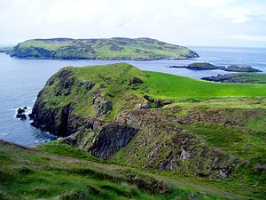
Calf of ManCalf of Man is an island of 618 acres (almost 1 square mile), off the southwest coast of the Isle of Man, from which main island it is separated by a narrow stretch of water called the Calf Sound. Like the nearby rocky islets of Chicken Rock and Kitterland, the Calf of Man is part of the parish of Rushen. The island has just two seasonal inhabitants. It is possible to reach the Calf of Man by boat from both Port Erin and Port St Mary. Cow Harbour and South Harbour are the main landing places. The highest part of the island is to the west where an unnamed peak reaches 415 feet above sea level. (Read more) |