Killead: Difference between revisions
Jump to navigation
Jump to search
Created page with "{{Infobox town |name=Killead |county=Antrim |picture=St Catherine's Parish Church (C of I) Killead - geograph.org.uk - 115746.jpg |picture caption=St Catherine's Church,..." |
No edit summary |
||
| Line 15: | Line 15: | ||
|constituency=South Antrim | |constituency=South Antrim | ||
}} | }} | ||
'''Killead''' is a small village in [[County Antrim]], near [[ | '''Killead''' is a small village in [[County Antrim]], near the village of [[Aldergrove]] and town of [[Antrim]]. It is along the A26 Tully Road. It had a recorded population of just 81 people at the 2011 Census. | ||
==Outside links== | ==Outside links== | ||
Latest revision as of 15:04, 17 September 2020
| Killead | |
| County Antrim | |
|---|---|
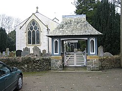
 St Catherine's Church, Killead | |
| Location | |
| Grid reference: | J173812 |
| Location: | 54°39’54"N, 6°10’50"W |
| Data | |
| Population: | 81 (2011) |
| Post town: | Crumlin |
| Postcode: | BT29 |
| Dialling code: | 028 |
| Local Government | |
| Council: | Antrim and Newtownabbey |
| Parliamentary constituency: |
South Antrim |
Killead is a small village in County Antrim, near the village of Aldergrove and town of Antrim. It is along the A26 Tully Road. It had a recorded population of just 81 people at the 2011 Census.
Outside links
| ("Wikimedia Commons" has material about Killead) |
