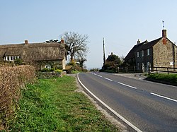
North Wootton, Dorset: Difference between revisions
Jump to navigation
Jump to search
Created page with "{{Infobox town |picture=North Wootton - geograph.org.uk - 386242.jpg |picture caption=North Wootton |name=North Wootton |county=Dorset |os grid ref=ST655145 |latitude=50.9285..." |
(No difference)
|
Latest revision as of 12:56, 12 June 2020
| North Wootton | |
| Dorset | |
|---|---|
 North Wootton | |
| Location | |
| Grid reference: | ST655145 |
| Location: | 50°55’43"N, 2°29’31"W |
| Data | |
| Population: | 50 (2013 est.) |
| Post town: | Sherborne |
| Postcode: | DT9 |
| Local Government | |
| Council: | Dorset |
| Parliamentary constituency: |
West Dorset |
North Wootton is a hamlet in Dorset, about a mile and a half south-east of Sherborne. It is sited on a narrow band of Cornbrash limestone, with Oxford clay adjacent to the south-east and Forest Marble to the north-west.[1] In 2013 the estimated population of the parish was 50.
The land of the parish has traditionally been owned by the owner of Sherborne Castle. From this connection, past owners have included Sir Walter Raleigh and Bishops of Salisbury. Residents of the parish previously had to take the deceased to Sherborne Abbey for burial; this arrangement stopped in 1618.[2]
Outside links
| ("Wikimedia Commons" has material about Wootton, Dorset North Wootton, Dorset) |
References
- ↑ Ralph Wightman (1983). Portrait of Dorset (4 ed.). Robert Hale Ltd. p. 18. ISBN 0-7090-0844-9.
- ↑ West Dorset, Holiday and Tourist Guide. West Dorset District Council. c. 1982. p. 14.
