Difference between revisions of "Purton, Lydney"
From Wikishire
(Created page with "{{Infobox town |name=Purton |county=Gloucestershire |picture=Purton House and Severn Estuary, Forest of Dean - geograph.org.uk - 90974.jpg |picture caption=The Severn and Purt...") |
(No difference)
|
Latest revision as of 18:07, 5 March 2020
| Purton | |
| Gloucestershire | |
|---|---|
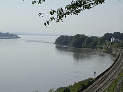
 The Severn and Purton House | |
| Location | |
| Grid reference: | SO670045 |
| Location: | 51°44’20"N, 2°28’42"W |
| Data | |
| Postcode: | GL15 |
| Local Government | |
| Council: | Forest of Dean |
Purton is a tiny hamlet on the western bank of the River Severn, where the river is a broad, tidal stream in the course of becoming the Severn Estuary. It stands opposite another Purton, to which it was once intimately linked by a ferry.
The western Purton is two miles north-east of Lydney at the edge of the Forest of Dean. The main railway line from Chepstow to Gloucester runs through Purton along the bank of the river.
Outside links
| ("Wikimedia Commons" has material about Purton, Lydney) |
