Churchend, Charfield: Difference between revisions
Jump to navigation
Jump to search
Created page with "{{Infobox town |name=Churchend |county=Gloucestershire |picture=St Michael's church, Churchend-geograph.org.uk-4052207.jpg |picture caption=St Michael and All Angels, Churchen..." |
m RB moved page Churchend, Gloucestershire to Churchend, Charfield: Ambiguity |
||
| (2 intermediate revisions by the same user not shown) | |||
| Line 2: | Line 2: | ||
|name=Churchend | |name=Churchend | ||
|county=Gloucestershire | |county=Gloucestershire | ||
|picture=St | |picture=St. James church, Churchend - geograph.org.uk - 195886.jpg | ||
|picture caption=St | |picture caption=St James, Churchend | ||
|os grid ref= ST718911 | |os grid ref= ST718911 | ||
|latitude=51.61807 | |latitude=51.61807 | ||
| Line 15: | Line 15: | ||
|constituency= | |constituency= | ||
}} | }} | ||
'''Churchend''' is a village in [[Gloucestershire]], half a mile south of [[Charfield]] and three miles south-west of [[ | '''Churchend''' is a village in [[Gloucestershire]], half a mile south of [[Charfield]] and three miles south-west of [[Wotton-under-Edge]]. | ||
The parish church stands here, from which the village is named. | The old parish church stands here, from which the village is named. The church, St James, stands on a steep hillside overlooking a valley, and today it is under the care of the Churches Conservation Trust.<ref>[http://www.visitchurches.org.uk/Ourchurches/Completelistofchurches/St-James-Church-Charfield-Gloucestershire/ St James' Church, Charfield, Gloucestershire]: Churches Conservation Trust]</ref> It is a Grade I listed building.<ref>{{NHLE|1321189|Church of St James, Charfield}}</ref> | ||
The church originates from the 13th century. It was largely rebuilt in the 15th century, using money from the local wool trade. During the 18th century the industry moved into the valley, isolating the church. It was repaired during the 1970s. | |||
==Outside links== | ==Outside links== | ||
Latest revision as of 13:57, 20 November 2019
| Churchend | |
| Gloucestershire | |
|---|---|
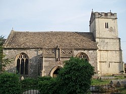
 St James, Churchend | |
| Location | |
| Grid reference: | ST718911 |
| Location: | 51°37’5"N, 2°24’27"W |
| Data | |
| Postcode: | GL12 |
| Local Government | |
| Council: | South Gloucestershire |
Churchend is a village in Gloucestershire, half a mile south of Charfield and three miles south-west of Wotton-under-Edge.
The old parish church stands here, from which the village is named. The church, St James, stands on a steep hillside overlooking a valley, and today it is under the care of the Churches Conservation Trust.[1] It is a Grade I listed building.[2]
The church originates from the 13th century. It was largely rebuilt in the 15th century, using money from the local wool trade. During the 18th century the industry moved into the valley, isolating the church. It was repaired during the 1970s.
Outside links
| ("Wikimedia Commons" has material about Churchend, Charfield) |
References
- ↑ St James' Church, Charfield, Gloucestershire: Churches Conservation Trust]
- ↑ National Heritage List 1321189: Church of St James, Charfield
