Newman's End: Difference between revisions
Created page with "{{Infobox town |name=Newman's End |county=Essex |picture=Village pump at Newman's End near Sheering - geograph.org.uk - 813384.jpg |picture caption=Cast iron pump, Newman's En..." |
|||
| Line 23: | Line 23: | ||
There are four Grade II listed structures at Newman's End: | There are four Grade II listed structures at Newman's End: | ||
*'Parsonage Farmhouse', a four bay timber framed and plastered two storey house, with | *'Parsonage Farmhouse', a four bay timber framed and plastered two storey house, with pargetting details, dating to the 17th century;<ref>{{NHLE|1337197Parsonage Farmhouse}}</ref> | ||
*'Parsonage Farm barn', a timber framed weatherboarded barn dating to the 17th century;<ref>{{NHLE|1111380|Barn east of Parsonage Farm}}</ref> | *'Parsonage Farm barn', a timber framed weatherboarded barn dating to the 17th century;<ref>{{NHLE|1111380|Barn east of Parsonage Farm}}</ref> | ||
*'Red Tile Cottages', a timber framed, tiled roofed cottage dating to the 16th century, and in 1609 part of Housham Hall manor;<ref>{{NHLE|1111379|Red Tile Cottages}}</ref> | *'Red Tile Cottages', a timber framed, tiled roofed cottage dating to the 16th century, and in 1609 part of Housham Hall manor;<ref>{{NHLE|1111379|Red Tile Cottages}}</ref> | ||
Latest revision as of 21:56, 11 June 2019
| Newman's End | |
| Essex | |
|---|---|
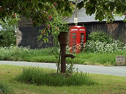
 Cast iron pump, Newman's End | |
| Location | |
| Grid reference: | TL516124 |
| Location: | 51°47’26"N, -0°11’51"E |
| Data | |
| Postcode: | CM17 |
| Dialling code: | 01279 |
| Local Government | |
| Council: | Epping Forest |
| Parliamentary constituency: |
Brentwood and Ongar |
Newman's End is a hamlet near Matching in western Essex and sharing its civil parish. The hamlet, at the north of the parish, is less than a mile north-west of Matching village and the parish church, St Mary's, and a mile south-east of the village of Sheering.
The M11 motorway is a mile to the west, beyond which sits Harlow.
History
At the then Smallway's Farm in the mid-1700s was a malt house, by at latest 1843 using grain from a field to the west of the farm. Parsonage Farm, still existing at the centre of the hamlet, of 63 acres in 1745 and 56 acres in 1843, was glebe land in the advowson of the trustees of Felsted School, until, in 1876, the rectory was bought by Henry Selwin-Ibbetson, 1st Baron Rookwood of Down Hall in the then Hatfield Broad Oak, now Hatfield Heath parish.[1] At the northeast of Parsonage Farm are the remains of a possible mediæval moat, now a scheduled monument.[2]
There are four Grade II listed structures at Newman's End:
- 'Parsonage Farmhouse', a four bay timber framed and plastered two storey house, with pargetting details, dating to the 17th century;[3]
- 'Parsonage Farm barn', a timber framed weatherboarded barn dating to the 17th century;[4]
- 'Red Tile Cottages', a timber framed, tiled roofed cottage dating to the 16th century, and in 1609 part of Housham Hall manor;[5]
- 'Pump on the Green', late 19th-century cast iron water pump[6]
See also
Outside links
| ("Wikimedia Commons" has material about Newman's End) |
References
- ↑ "Matching": A History of the County of Essex - Volume 8 : {{{2}}} (Victoria County History)
- ↑ National Monuments Record: No. 373305 – Possible moat
- ↑ National Heritage List 1337197Parsonage Farmhouse: Farmhouse Newman's End
- ↑ National Heritage List 1111380: Barn east of Parsonage Farm
- ↑ National Heritage List 1111379: Red Tile Cottages
- ↑ National Heritage List 1308894: Pump on Green
