Boscastle: Difference between revisions
Created page with '{{Infobox town |name=Boscastle |county=Cornwall |os grid ref=SX098906 |latitude=50.6840 |longitude=-4.6929 |picture=Boscastle path.JPG |picture caption=Boscastle |population=888…' |
|||
| Line 53: | Line 53: | ||
Boscastle was flooded again on 21 June 2007 although the scale of destruction was not nearly as serious as in 2004. | Boscastle was flooded again on 21 June 2007 although the scale of destruction was not nearly as serious as in 2004. | ||
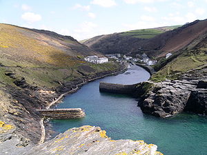
[[File: | [[File:BocastlePICT0052 2004.jpg|right|thumb|300px|Boscastle harbour and landscape]] | ||
==Outside links== | ==Outside links== | ||
{{commons}} | {{commons}} | ||
Latest revision as of 18:32, 5 April 2019
| Boscastle | |
| Cornwall | |
|---|---|
 Boscastle | |
| Location | |
| Grid reference: | SX098906 |
| Location: | 50°41’2"N, 4°41’34"W |
| Data | |
| Population: | 888 (2001) |
| Post town: | Boscastle |
| Postcode: | PL35 |
| Dialling code: | 01840 |
| Local Government | |
| Council: | Cornwall |
| Parliamentary constituency: |
North Cornwall |
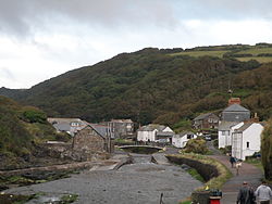
Boscastle is a village and fishing port on the north coast of Cornwall. It is 14 miles south of Bude and 5 miles northeast of Tintagel, tucked at the bottom of a deep, steep valley, cut by a little river which has been its fortune and, on occasion, its curse.
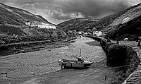
Boscastle harbour is a natural inlet protected by two stone harbour walls built in 1584 by Sir Richard Grenville (the hero of HMS Revenge). It is the only significant harbour for 20 miles along the coast. As well as its primary occupation as a fishing harbour, Boscastle Harbour has seen heavy imports too; Boscastle was once a small port (similar to many others on the north coast of Cornwall), importing limestone and coal and exporting slate and other local produce.
The oldest part of Boscastle surrounds the harbour; more modern residential building extends up the valleys of the River Valency and River Jordan.
Boscastle lies within the Cornwall Area of Outstanding Natural Beauty (AONB); almost a third of Cornwall has AONB designation.
Name
The name of the village comes from Botreaux Castle (pronounced "But'ry"), a 12th-century motte-and-bailey fortress, of which few remains survive. The castle was anciently in the possession of the de Botreaux family, which became under William de Botereaux (1337–91) the Barons Botreaux.


Tourism
The village, with its picturesque harbour, is a popular tourist destination. Among the attractions are the Boscastle pottery shop, and access to the South West Coast Path.
Much of the land in and around Boscastle is owned by the National Trust, including both sides of the harbour, Forrabury Stitches, high above the Boscastle and divided into ancient "stitchmeal" cultivation plots, and large areas of the Valency Valley, known for its connections to Thomas Hardy.
The former harbour stables (part of the National Trust estate) are now a youth hostel popular with walkers. The National Trust runs a shop at the harbour,[1] and a visitor centre in the Old Smithy.
Church
The Rector of Boscastle is responsible for seven churches in the district: Forrabury (St Symphorian), Minster (St Merthiana), St Juliot, Lesnewth (St Michael and All Angels), Trevalga (St Petroc), Otterham (St Denis) and Davidstow (St David).[2]
St Juliot in Lesnewth is of particular interest to devotees of the works of Thomas Hardy since he acted as the architect for the church's restoration in March 1870 and this is where he met his first wife, Emma Gifford, who was the Rector's sister-in-law. Their love affair was the inspiration for his novel A Pair of Blue Eyes and later in life, some of his poetry.
In 2004 British television channel BBC 2 began broadcasting A Seaside Parish, a weekly series focusing on the life of the newly appointed Rector of Boscastle, Christine Musser.[3]
Boscastle and Crackington Haven floods
On 16 August 2004, heavy rain drove a huge voume of water plunging down the narrow valley; the river rose and a flash flood poured over the village causing extensive damage to the village. Residents were trapped in houses as the lanes turned into rivers: people were trapped on roofs, in cars, in buildings and on the river's banks. The flood burst through walls and the bridge and the visitor centre were washed away.[4][5] At the same time, the same event was happening in the neighbouring valley, where Crackington Haven faced a flood just as devastating.
Two Royal Air Force Westland Sea King rescue helicopters from Chivenor, three Royal Navy Sea Kings from Culdrose, one RAF Sea King from RAF St Mawgan and one Coastguard S61 helicopter from Portland searched for and assisted casualties in and around the village.
The operation was coordinated by the Aeronautical Rescue Coordination Centre (ARCC) based at RAF Kinloss in the largest peacetime rescue operation ever launched in the United Kingdom. A total of 91 people were rescued and there were no fatalities, only one broken thumb.
Around 50 cars were swept into the harbour and the bridge was washed away, roads were submerged under 9 feet of water, making communication effectively impossible until flood-waters subsided. The sewerage system burst, and for this range of health and safety reasons Boscastle was declared temporarily inaccessible.
Boscastle was flooded again on 21 June 2007 although the scale of destruction was not nearly as serious as in 2004.

Outside links
| ("Wikimedia Commons" has material about Boscastle) |
- Village website
- Boscastle - National Trust
References
- ↑ http://www.visitboscastleandtintagel.com/boscastle-and-tintagel/thedms.asp?dms=13&venue=4520516
- ↑ Boscastle group of 7 Churches
- ↑ "Seaside priest is TV star". BBC News. 1 February 2004. http://news.bbc.co.uk/1/hi/england/cornwall/3445601.stm. Retrieved 2008-08-25.
- ↑ BBC news:Dozens rescued from flash floods Retrieved on 25 August 2008
- ↑ Met office
