Luggala: Difference between revisions
Created page with "{{Infobox hill |name=Luggala |irish=Log an Lágh |county=Wicklow |picture=Lough Tay.jpg |picture caption=Luggala behind Lough Tay |os grid ref=O178103 |latitude=53.130824 |lon..." |
No edit summary |
||
| Line 6: | Line 6: | ||
|picture caption=Luggala behind Lough Tay | |picture caption=Luggala behind Lough Tay | ||
|os grid ref=O178103 | |os grid ref=O178103 | ||
|latitude=53. | |latitude=53.105833 | ||
|longitude=-6. | |longitude=-6.283611 | ||
|height=1,952 feet | |height=1,952 feet | ||
|range=Wicklow Mountains | |range=Wicklow Mountains | ||
| Line 15: | Line 15: | ||
The name 'Luggala' is from the Irish ''Log an Lágh'', meaning 'Hollow of the hill'. The alternative, 'Fancy Mountain' is not apparently a plain English description but is said to be from the Irish ''Fuinnse'', meaning 'Ash tree'.<ref>[http://www.logainm.ie/1166419.aspx Placenames Database of Ireland]</ref><ref>[http://homepage.tinet.ie/~hluskin/luggala.htm Luggala]</ref><ref>[http://www.karanagai.com/?p=69 KaraNagai.com : Lough Dan] {{webarchive|url=https://web.archive.org/web/20070927225900/http://www.karanagai.com/?p=69 |date=2007-09-27 }}</ref> | The name 'Luggala' is from the Irish ''Log an Lágh'', meaning 'Hollow of the hill'. The alternative, 'Fancy Mountain' is not apparently a plain English description but is said to be from the Irish ''Fuinnse'', meaning 'Ash tree'.<ref>[http://www.logainm.ie/1166419.aspx Placenames Database of Ireland]</ref><ref>[http://homepage.tinet.ie/~hluskin/luggala.htm Luggala]</ref><ref>[http://www.karanagai.com/?p=69 KaraNagai.com : Lough Dan] {{webarchive|url=https://web.archive.org/web/20070927225900/http://www.karanagai.com/?p=69 |date=2007-09-27 }}</ref> | ||
Luggala is about 28 miles | Luggala is about 28 miles south-west of [[Dublin]]. | ||
==Luggala Estate== | ==Luggala Estate== | ||
Latest revision as of 21:08, 28 January 2019
| Luggala | |||
| County Wicklow | |||
|---|---|---|---|
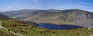
 Luggala behind Lough Tay | |||
| Range: | Wicklow Mountains | ||
| Summit: | 1,952 feet O178103 53°6’21"N, 6°17’1"W | ||
Luggala, also called Fancy Mountain, is a mountain of 1,952 feet in the Wicklow Mountains, in County Wicklow. Its cliffs rise above a pretty lake, Lough Tay, and are a popular location for rock climbing.
The name 'Luggala' is from the Irish Log an Lágh, meaning 'Hollow of the hill'. The alternative, 'Fancy Mountain' is not apparently a plain English description but is said to be from the Irish Fuinnse, meaning 'Ash tree'.[1][2][3]
Luggala is about 28 miles south-west of Dublin.
Luggala Estate
The mountain forms a part of the Luggala Estate (also known as the Guinness Estate), which spreads over 10 square miles. The estate was owned by wealthy arts patron Garech Browne, a member of the Guinness family. The buildings on the estate, including the luxurious Luggala Lodge (known as "Luggala Castle"), are rented commercially year-round.[4][5]
The estate has been used as the location of some major films, including Zardoz, Braveheart and Excalibur, as well as the historical drama television series Vikings. The property was put on the market in 2017, with an asking price of €28 million.[6]
Rock climbing
The granite crag on Luggala has been popular with rock climbers ever since the first routes were established by members of the Irish Mountaineering Club in 1949. It is, however, not as popular as Glendalough, despite being of comparable quality and size, and closer to Dublin. The current guidebook]], published in 2009, lists 188 routes; grades]] go up to E5 and lengths up to 525 feet, but 200 feet (two pitches) at HVS/5a is fairly typical. The climbing is generally good quality, with excellent friction, but the routes can often follow meandering lines and be hard to find. Protection varies; in accordance with Irish climbing ethics, bolts are not used.[7]
The crag can be approached through the main entrance of the Luggala Estate, skirting the lakeshore. However, many climbers, not wishing to intrude on the residents' privacy, prefer to approach from the high-level road at the back of the mountain, doing a short uphill hike before descending a gully to the base of the crag.
Outside links
References
- ↑ Placenames Database of Ireland
- ↑ Luggala
- ↑ KaraNagai.com : Lough Dan Template:Webarchive
- ↑ Luggala Lodge
- ↑ Mark Keenan (2014-03-14). "€80,000 per month...the real price of disappearing". Irish Independent. http://www.independent.ie/lifestyle/property-homes/80000-per-monththe-real-price-of-disappearing-30090617.html. Retrieved 2014-03-14.
- ↑ Lyons, Madeline (2017-01-25). "Guinness ancestral home in Wicklow goes on sale for €28m". The Irish Times. https://www.irishtimes.com/life-and-style/homes-and-property/new-to-market/guinness-ancestral-home-in-wicklow-goes-on-sale-for-28m-1.2951245. Retrieved 2018-11-22.
- ↑ Lyons, Joe and Fenlon, Robbie: 'Rock Climbing Guide to Wicklow' (Mountaineering Council of Ireland, 1993) ISBN 978-0-902940-11-6