Kyloe: Difference between revisions
Jump to navigation
Jump to search
Created page with "{{Infobox town |name=Kyloe |county=Northumberland |picture=Kyloe Church, Northumberland - geograph.org.uk - 79261.jpg |picture caption=Kyloe Church |os grid ref=NU045395..." |
No edit summary |
||
| Line 15: | Line 15: | ||
|constituency=Berwick-upon-Tweed | |constituency=Berwick-upon-Tweed | ||
}} | }} | ||
'''Kyloe''' is a village an parish in [[Northumberland]], about eight miles | '''Kyloe''' is a village an parish in [[Northumberland]], about eight miles south-east of [[Berwick-on-Tweed]]. | ||
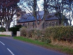
The former church in Kyloe was built in the eighteenth century, replacing a mediæval building, and is now a private house. | The former church in Kyloe was built in the eighteenth century, replacing a mediæval building, and is now a private house. | ||
| Line 32: | Line 32: | ||
==References== | ==References== | ||
{{reflist}} | {{reflist}} | ||
[[Category:Islandshire]] | |||
Latest revision as of 17:08, 4 October 2018
| Kyloe | |
| Northumberland | |
|---|---|
 Kyloe Church | |
| Location | |
| Grid reference: | NU045395 |
| Location: | 55°38’56"N, 1°55’48"W |
| Data | |
| Population: | 323 (2001) |
| Post town: | Berwick Upon Tweed |
| Postcode: | TD15 |
| Local Government | |
| Council: | Northumberland |
| Parliamentary constituency: |
Berwick-upon-Tweed |
Kyloe is a village an parish in Northumberland, about eight miles south-east of Berwick-on-Tweed.
The former church in Kyloe was built in the eighteenth century, replacing a mediæval building, and is now a private house.
At East Kyloe, the ruins of a late 14th or early 15th century mediæval tower house known as Kyloe Tower now form part of a complex of farm buildings.[1]
The nearby woodland area is a famous area for rock climbing and bouldering. Known locally as 'Kyloe-In-The-Woods' or simply 'The Woods', the crags are home to some of the toughest climbs in the United Kingdom.
Outside links
| ("Wikimedia Commons" has material about Kyloe) |
- Explore Berwick
- Bouldering in Northumberland
- Information on Kyloe from GENUKI
- Kyloe church converted into a home
