Y Garn (Glyderau): Difference between revisions
No edit summary |
No edit summary |
||
| Line 6: | Line 6: | ||
|picture caption=Y Garn from Tryfan | |picture caption=Y Garn from Tryfan | ||
|height=3,107 feet | |height=3,107 feet | ||
|latitude=53.115033 | |||
|longitude=-4.048371 | |||
|os grid ref=SH630595 | |os grid ref=SH630595 | ||
}} | }} | ||
| Line 12: | Line 14: | ||
The mountain is one of the "[[Welsh 3000s]]"; the 15 summits in Wales over 3,000 feet in height, all of which are in Caernarfonshire. Y Garn is the tenth-highest peak of them all. Moderate snow accumulations can take place on the western slopy side of the mountain from October to May. | The mountain is one of the "[[Welsh 3000s]]"; the 15 summits in Wales over 3,000 feet in height, all of which are in Caernarfonshire. Y Garn is the tenth-highest peak of them all. Moderate snow accumulations can take place on the western slopy side of the mountain from October to May. | ||
The south-westerly side of the mountain slopes gently down to the [[Nant Peris]] valley. The other, north-easterly side is of a different character, consisting of two steeply sided corries, Cwm Clyd and Cwm Cywion, and finally [[Llyn Idwal]] and Ogwen Cottage. Along the ridge to the north lies [[Elidir Fawr]], while to the south-east is the top of the Devil's Kitchen and [[Glyder Fawr]].<ref>Nuttall, John & Anne (1999). The Mountains of England & Wales - Volume 1: Wales (2nd edition ed.). Milnthorpe: Cicerone. ISBN 1-85284-304-7.</ref> | The south-westerly side of the mountain slopes gently down to the [[Nant Peris]] valley. The other, north-easterly side is of a different character, consisting of two steeply sided corries, Cwm Clyd and Cwm Cywion, and finally [[Llyn Idwal]] and [[Ogwen Cottage]]. Along the ridge to the north lies [[Elidir Fawr]], while to the south-east is the top of the Devil's Kitchen and [[Glyder Fawr]].<ref>Nuttall, John & Anne (1999). The Mountains of England & Wales - Volume 1: Wales (2nd edition ed.). Milnthorpe: Cicerone. ISBN 1-85284-304-7.</ref> | ||
==References== | ==References== | ||
Latest revision as of 10:14, 14 September 2018
| Y Garn | |||
| Caernarfonshire | |||
|---|---|---|---|
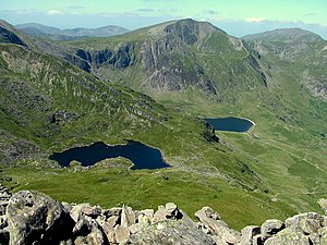
 Y Garn from Tryfan | |||
| Range: | Snowdonia | ||
| Summit: | 3,107 feet SH630595 53°6’54"N, 4°2’54"W | ||
Y Garn is a mountain in Snowdonia, in Caernarfonshire. Y Garn forms part of the Glyderau range of Snowdonia.
The mountain is one of the "Welsh 3000s"; the 15 summits in Wales over 3,000 feet in height, all of which are in Caernarfonshire. Y Garn is the tenth-highest peak of them all. Moderate snow accumulations can take place on the western slopy side of the mountain from October to May.
The south-westerly side of the mountain slopes gently down to the Nant Peris valley. The other, north-easterly side is of a different character, consisting of two steeply sided corries, Cwm Clyd and Cwm Cywion, and finally Llyn Idwal and Ogwen Cottage. Along the ridge to the north lies Elidir Fawr, while to the south-east is the top of the Devil's Kitchen and Glyder Fawr.[1]
References
- ↑ Nuttall, John & Anne (1999). The Mountains of England & Wales - Volume 1: Wales (2nd edition ed.). Milnthorpe: Cicerone. ISBN 1-85284-304-7.