End Hill: Difference between revisions
Jump to navigation
Jump to search
mNo edit summary |
No edit summary |
||
| (One intermediate revision by one other user not shown) | |||
| Line 3: | Line 3: | ||
|county 1=Herefordshire | |county 1=Herefordshire | ||
|county 2=Worcestershire | |county 2=Worcestershire | ||
|range=Malvern Hills | |||
|picture=End Hill and the Teme valley - geograph.org.uk - 646681.jpg | |picture=End Hill and the Teme valley - geograph.org.uk - 646681.jpg | ||
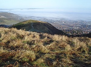
|picture caption=End Hill from the south | |picture caption=End Hill from the south | ||
|height=1,079 feet | |height=1,079 feet | ||
|os grid ref=SO767467 | |os grid ref=SO767467 | ||
|latitude=52.118122 | |||
|longitude=-2.341702 | |||
}} | }} | ||
'''End Hill''' is the northernmost hill of the [[Malvern Hills]], the northern peak at the end of that long ridge. Its summit reaches 1,079 feet above sea level and is on the border of [[Herefordshire]] and [[Worcestershire]]. | '''End Hill''' is the northernmost hill of the [[Malvern Hills]], the northern peak at the end of that long ridge. Its summit reaches 1,079 feet above sea level and is on the border of [[Herefordshire]] and [[Worcestershire]]. | ||
{{Commonscat|End_hill,_Malvern_hills}} | {{Commonscat|End_hill,_Malvern_hills}} | ||
Latest revision as of 15:52, 11 September 2018
| End Hill | |||
| Herefordshire, Worcestershire | |||
|---|---|---|---|
 End Hill from the south | |||
| Range: | Malvern Hills | ||
| Summit: | 1,079 feet SO767467 52°7’5"N, 2°20’30"W | ||
End Hill is the northernmost hill of the Malvern Hills, the northern peak at the end of that long ridge. Its summit reaches 1,079 feet above sea level and is on the border of Herefordshire and Worcestershire.
| ("Wikimedia Commons" has material about End Hill) |
