Slieve Muck: Difference between revisions
Jump to navigation
Jump to search
Created page with '{{Infobox hill |name=Slieve Muck |county=County Down |range=Mourne Mountains |picture=Mourne countryside at Slievenagore - geograph.org.uk - 1205489.jpg |picture caption=The sout…' |
No edit summary |
||
| Line 7: | Line 7: | ||
|height=2,211 feet | |height=2,211 feet | ||
|os grid ref=J282250 | |os grid ref=J282250 | ||
|latitude=54.1580501 | |||
|longitude=-6.0396521 | |||
}} | }} | ||
'''Slieve Muck''' is one of the [[Mourne Mountains]] in [[County Down]]. | '''Slieve Muck''' is one of the [[Mourne Mountains]] in [[County Down]]. | ||
It rises to a summit at 2,211 feet, which summit overlooks Spelga Dam and the Deer's Meadow, the source of the [[River Bann]]. | It rises to a summit at 2,211 feet, which summit overlooks Spelga Dam and the Deer's Meadow, the source of the [[River Bann]]. | ||
Latest revision as of 16:31, 28 August 2018
| Slieve Muck | |||
| County Down | |||
|---|---|---|---|
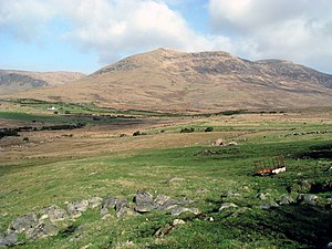
 The southern slopes of Slieve Muck | |||
| Range: | Mourne Mountains | ||
| Summit: | 2,211 feet J282250 54°9’29"N, 6°2’23"W | ||
Slieve Muck is one of the Mourne Mountains in County Down.
It rises to a summit at 2,211 feet, which summit overlooks Spelga Dam and the Deer's Meadow, the source of the River Bann.