Difference between revisions of "Stanford, Kent"
From Wikishire
(Created page with "{{infobox town |name=Stanford |county=Kent |picture=The Drum Inn, Stanford, Kent, UK.jpg |picture caption=The Drum Inn |latitude=51.103 |longitude=1.0403 |population=429 |cens...") |
(No difference)
|
Revision as of 08:23, 17 July 2018
| Stanford | |
| Kent | |
|---|---|
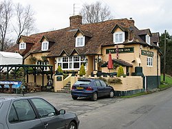
 The Drum Inn | |
| Location | |
| Location: | 51°6’11"N, 1°2’25"E |
| Data | |
| Population: | 429 (2011[1]) |
| Post town: | Ashford |
| Postcode: | TN25 |
| Dialling code: | 01303 |
| Local Government | |
| Council: | Folkestone and Hythe |
| Parliamentary constituency: |
Folkestone and Hythe |
Stanford is a village and parish in Kent, partly in the hundred of Stowting, and partly in that of Street, close to Folkestone.
It has been divided by the M20 into Stanford North and Stanford South. The Stanford Windmill is to the north of the M20 and west of the ancient Roman Stone Street. The parish church is All Saints. The 2011 Census population includes the village of Westenhanger.
References
- ↑ Office for National Statistics. "Parish population 2011". UK government. http://www.neighbourhood.statistics.gov.uk/dissemination/LeadKeyFigures.do?a=7&b=11128954&c=CT21+4HR&d=16&e=62&g=6438461&i=1001x1003x1032x1004&m=0&r=0&s=1444042121115&enc=1. Retrieved 31 January 2017.
Outside links
| ("Wikimedia Commons" has material about Stanford, Kent) |