Template:FP-Dun Rig: Difference between revisions
Jump to navigation
Jump to search
Created page with "{{#switch:{{{1}}} |pic=Upper Glen Sax and Dun Rig - geograph.org.uk - 1534824.jpg |cap= Upper Glen Sax and Dun Rig in Selkirkshire |text='''Dun Rig''' is a hill amongst the Ma..." |
No edit summary |
||
| Line 1: | Line 1: | ||
{{#switch:{{{1}}} | {{#switch:{{{1}}} | ||
|pic=Upper Glen Sax and Dun Rig - geograph.org.uk - 1534824.jpg | |pic=Upper Glen Sax and Dun Rig - geograph.org.uk - 1534824.jpg | ||
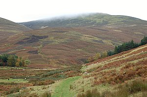
|cap= Upper Glen Sax and Dun Rig in Selkirkshire | |cap=Upper Glen Sax and Dun Rig in Selkirkshire | ||
|text='''Dun Rig''' is a hill amongst the Manor Hills, part of the Southern Uplands. It reaches 2,441 feet and is the county top of [[Selkirkshire]]. | |text='''Dun Rig''' is a hill amongst the Manor Hills, part of the Southern Uplands. It reaches 2,441 feet and is the county top of [[Selkirkshire]]. | ||
Latest revision as of 20:45, 11 July 2018
 |
Dun RigDun Rig is a hill amongst the Manor Hills, part of the Southern Uplands. It reaches 2,441 feet and is the county top of Selkirkshire. Dun Rig is a hill of two summits and two counties. Each of its summits forms a turning point on the boundary between the two shires of Selkirk and Peebles, while the saddle between them at the head of Upper Glen Sax is left to Selkirkshire alone. The name 'Dun Rig' ('brown ridge') is a common one in the Middle Shires, but that at the head of Glen Sax is the best known. (Read more) |