Herefordshire Beacon: Difference between revisions
Created page with '{{Infobox hill |name=Herefordshire Beacon |county=Herefordshire |picture=British_Camp_-_geograph.org.uk_-_16198.jpg |picture caption=Herefordshire Beacon |height=1,109 feet |rang…' |
No edit summary |
||
| Line 7: | Line 7: | ||
|range=Malvern Hills | |range=Malvern Hills | ||
|os grid ref=SO759400 | |os grid ref=SO759400 | ||
|latitude=52.057852 | |||
|longitude=-2.352909 | |||
}} | }} | ||
The '''Herefordshire Beacon''' is one of the hills of the [[Malvern Hills]]; a counterpart to the nearby [[Worcestershire Beacon]], also among the Malvern Hills. Its summit is in [[Herefordshire]], though the county | The '''Herefordshire Beacon''' is one of the hills of the [[Malvern Hills]]; a counterpart to the nearby [[Worcestershire Beacon]], also among the Malvern Hills. Its summit is in [[Herefordshire]], though the county border runs over its eastern slopes. | ||
The summit of the Herefordshire Beacon is 1,109 feet above sea level, though the Victorian era inscription at the foot of the hill puts its height at 1,145 feet. It is surrounded by a British Iron Age hill fort earthwork known as British Camp. | The summit of the Herefordshire Beacon is 1,109 feet above sea level, though the Victorian era inscription at the foot of the hill puts its height at 1,145 feet. It is surrounded by a British Iron Age hill fort earthwork known as British Camp. | ||
The | The border between [[Herefordshire]] and [[Worcestershire]] is about 100 yards east of the summit, marked by the Shire Ditch. Local legend has it that the Shire Ditch was built as a settlement of a boundary dispute, but archaeologists place its origin much earlier, perhaps at the date that the Iron Age hillforts were built on the Beacon and on the hills hereabouts. | ||
[[British Camp]], the hillfort has two ages' work in it: the hill fort itself is from the Iron Age, predating the Roman invasion. The Citadel on top however is mediæval, for a castle stood here. | [[British Camp]], the hillfort has two ages' work in it: the hill fort itself is from the Iron Age, predating the Roman invasion. The Citadel on top however is mediæval, for a castle stood here. | ||
Latest revision as of 14:41, 24 April 2018
| Herefordshire Beacon | |||
| Herefordshire | |||
|---|---|---|---|
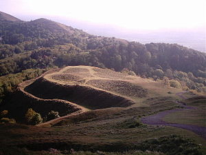
 Herefordshire Beacon | |||
| Range: | Malvern Hills | ||
| Summit: | 1,109 feet SO759400 52°3’28"N, 2°21’10"W | ||
The Herefordshire Beacon is one of the hills of the Malvern Hills; a counterpart to the nearby Worcestershire Beacon, also among the Malvern Hills. Its summit is in Herefordshire, though the county border runs over its eastern slopes.
The summit of the Herefordshire Beacon is 1,109 feet above sea level, though the Victorian era inscription at the foot of the hill puts its height at 1,145 feet. It is surrounded by a British Iron Age hill fort earthwork known as British Camp.
The border between Herefordshire and Worcestershire is about 100 yards east of the summit, marked by the Shire Ditch. Local legend has it that the Shire Ditch was built as a settlement of a boundary dispute, but archaeologists place its origin much earlier, perhaps at the date that the Iron Age hillforts were built on the Beacon and on the hills hereabouts.
British Camp, the hillfort has two ages' work in it: the hill fort itself is from the Iron Age, predating the Roman invasion. The Citadel on top however is mediæval, for a castle stood here.