Bush Ground: Difference between revisions
Jump to navigation
Jump to search
Created page with ''''The Bush Ground''' is a field at {{getmapecho|TL0472071050}} which is part of Bottom Farm, at Covington in Huntingdonshire. The field runs up to the border with [[Nor…' |
No edit summary |
||
| (3 intermediate revisions by one other user not shown) | |||
| Line 1: | Line 1: | ||
''' | {{county|Huntingdon}} | ||
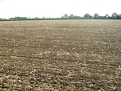
[[File:Bush Ground - Huntingdonshire county top.jpg|right|thumb|250px|Bush Ground, after harvest]] | |||
'''Bush Ground''' is a field which is part of Bottom Farm, at [[Covington]] in [[Huntingdonshire]]. The field runs up to the border with [[Northamptonshire]] (and is just north of the three shires point of Huntingdonshire-Northamptonshire-[[Bedfordshire]]). | |||
The significance of | The field has borne its name for many years. In the eighteenth century it was part of the estates of the Duke of Manchester, and is referred to in correspondence at the time as "Bushy Ground". | ||
The significance of Bush Ground is that it is the highest point in Huntingdonshire: the [[county top]]. Of all the [[counties of the United Kingdom]], Huntingdonshire's is the lowest highest point, at 263 feet. | |||
==Outside links== | |||
*Location map: {{wmap|52.3276|-0.4648|zoom=14}} | |||
*Streetmap: {{map|TL0472071050}} | |||
[[Category:County tops]] [[Category:Huntingdonshire]] | [[Category:County tops]] [[Category:Huntingdonshire]] | ||
Latest revision as of 10:23, 10 March 2018

Bush Ground is a field which is part of Bottom Farm, at Covington in Huntingdonshire. The field runs up to the border with Northamptonshire (and is just north of the three shires point of Huntingdonshire-Northamptonshire-Bedfordshire).
The field has borne its name for many years. In the eighteenth century it was part of the estates of the Duke of Manchester, and is referred to in correspondence at the time as "Bushy Ground".
The significance of Bush Ground is that it is the highest point in Huntingdonshire: the county top. Of all the counties of the United Kingdom, Huntingdonshire's is the lowest highest point, at 263 feet.
Outside links
- Location map: 52°19’39"N, 0°27’53"W
- Streetmap: TL0472071050