Marsden Rock: Difference between revisions
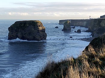
Created page with "right|thumb|350px|Marsden Bay and the Marsden Rock {{county|Durham}} '''Marsden Rock''' is a rock formation..." |
|||
| Line 31: | Line 31: | ||
[[Category:Sea stacks of County Durham]] | [[Category:Sea stacks of County Durham]] | ||
[[Category:National Trust properties in County Durham]] | |||
Latest revision as of 22:53, 13 February 2018

Marsden Rock is a rock formation on the coast of County Durham, standing in the North Sea by Marsden. Once much grander the rock has been eroded by the sea and the wind into frequently changing shapes and in 1997 much of it was blown up for safety reasons, in case of collapse onto a popular beach.
The rock is owned by the National Trust. The rock is reachable on foot during low tide, but is completely surrounded by water at high tide.
The Marsden Grotto, built into a cave in the cliff, looks out on the rock.
The changing rock
The Marsden Rock today stands 100 feet high. It is a sea stack of periclase and Magnesian Limestone which lies approximately 100 yards off the main cliff face. In 1803 a flight of steps was constructed up the side of the rock. In 1903 several choirs climbed onto the rock to perform a choral service. A juggling show was also performed by a group of trainee clowns who worked for Marsden Quarry.
In 1911 a large section of the rock collapsed into the sea leaving it as an arch. Continued tidal erosion caused the arch to collapse in 1996, splitting the rock into two separate stacks. Before this great sundering, the arch had featured on many local postcards and photographs.
In 1997 the smaller stack was declared unsafe and was demolished in the interests of public safety.
Wildlife
The rock is home to seabird colonies, with thousands of pairs of black-legged kittiwakes, northern fulmar|fulmars, gulls and cormorants.
Pictures
-
In 1969, from the south
-
In 1974, from the south
-
In 2005, from the north (after collapse of the arch and demolition of the smaller remaining stack)
-
From the clifftop
Outside links
| ("Wikimedia Commons" has material about Marsden Rock) |
- Location map: 54°58’39"N, 1°22’32"W
- Blowing up the rock


