Rowardennan: Difference between revisions
Jump to navigation
Jump to search
Created page with "{{infobox town |county=Stirling |gaelic=Rubha Aird Eònain |os grid ref=NS360990 |latitude=56.1553 |longitude=-4.6420 |LG district=Stirling |constituency=Stirling |post town=G..." |
(No difference)
|
Latest revision as of 10:30, 3 October 2017
| Rowardennan Gaelic: Rubha Aird Eònain | |
| Stirlingshire | |
|---|---|
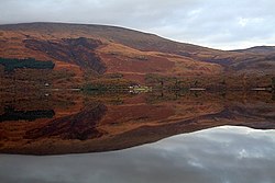
 Looking east across Loch Lomond to Rowardennan | |
| Location | |
| Grid reference: | NS360990 |
| Location: | 56°9’19"N, 4°38’31"W |
| Data | |
| Post town: | Glasgow |
| Postcode: | G63 |
| Dialling code: | 01360 |
| Local Government | |
| Council: | Stirling |
| Parliamentary constituency: |
Stirling |
Rowardennan is a small rural community on the eastern shore of Loch Lomond in Stirlingshire.[1] It is mainly known as the starting point for the main path up Ben Lomond.[2]
Rowardennan is at the northern end of the public road, but the West Highland Way passes through the area and continues north along the side of the loch. Rowardennan has a hostel and camping for hikers on the West Highland Way. A small passenger ferry crosses the loch to Tarbet on the opposite shore. Rowardennan has a hotel, hostel and chalet accommodation.
It appears as "Dennan's Row" in Walter Scott's poem |The Lady of the Lake.
References
- ↑ "Rowardennan". Gazetteer for Scotland. http://www.scottish-places.info/towns/townfirst4853.html. Retrieved 15 December 2014.
- ↑ Walking the West Highland Way. Lonely Planet. https://books.google.co.uk/books?id=FQC07SWSIrIC&pg=PT18&dq=Rowardennan&hl=en&sa=X&ei=5qaOVMq0BeO57gaVxoGQCA&ved=0CEUQuwUwAg#v=onepage&q=Rowardennan&f=false.
Outside links
| ("Wikimedia Commons" has material about Rowardennan) |
This Stirlingshire article is a stub: help to improve Wikishire by building it up.
