Llanrhystud: Difference between revisions
Jump to navigation
Jump to search
Created page with "{{Infobox town | name= Llanrhystud | county=Cardiganshire | picture=Llanrhystud,_Ceredigion.jpg | picture caption = Village and church from the bridleway to Castell-bach | pop..." |
|||
| (One intermediate revision by the same user not shown) | |||
| Line 21: | Line 21: | ||
*[http://www.llanrhystud.co.uk/about.shtml Llanrhystud - Extract from "A Topographical Dictionary of Wales" by Samuel Lewis 1833] | *[http://www.llanrhystud.co.uk/about.shtml Llanrhystud - Extract from "A Topographical Dictionary of Wales" by Samuel Lewis 1833] | ||
*[http://www.geograph.org.uk/search.php?i=3090745 www.geograph.co.uk : photos of Llanrhystud and surrounding area] | *[http://www.geograph.org.uk/search.php?i=3090745 www.geograph.co.uk : photos of Llanrhystud and surrounding area] | ||
[[Category:Beaches of Cardiganshire]] | |||
{{stub}} | {{stub}} | ||
Latest revision as of 13:51, 8 December 2016
| Llanrhystud | |
| Cardiganshire | |
|---|---|
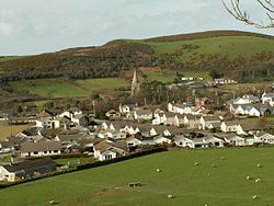
 Village and church from the bridleway to Castell-bach | |
| Location | |
| Grid reference: | SN538697 |
| Location: | 52°18’21"N, 4°8’45"W |
| Data | |
| Post town: | Aberystwyth |
| Postcode: | SY23 |
| Dialling code: | 01970 |
| Local Government | |
| Council: | Ceredigion |
| Parliamentary constituency: |
Ceredigion |
Llanrhystud is a medium-sized seaside village in Cardiganshire. It is situated on the A487 road, nine miles south of Aberystwyth. It is named after the early Christian saint Rhystud.
Outside links
- Llanrhystud Village Information
- Llanrhystud - Extract from "A Topographical Dictionary of Wales" by Samuel Lewis 1833
- www.geograph.co.uk : photos of Llanrhystud and surrounding area

This Cardiganshire article is a stub: help to improve Wikishire by building it up.