King's Sedgemoor: Difference between revisions
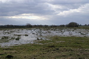
Created page with "{{county|Somerset}} thumb|300px|King's Sedgemoor '''King's Sedgemoor''' is a piece of rich animal habitat and farming land, that forms part of the..." |
mNo edit summary |
||
| Line 3: | Line 3: | ||
'''King's Sedgemoor''' is a piece of rich animal habitat and farming land, that forms part of the Somerset Levels and Moors in [[Somerset]]. | '''King's Sedgemoor''' is a piece of rich animal habitat and farming land, that forms part of the Somerset Levels and Moors in [[Somerset]]. | ||
The area of King's Sedgemoor falls within the [[Whitley Hundred | The area of King's Sedgemoor falls within the [[Whitley Hundred|Whitley]] [[Hundred]],<ref>{{cite web|title=Somerset Hundreds|url=http://www.genuki.org.uk/big/eng/SOM/Miscellaneous/|publisher=GENUKI|accessdate=22 October 2011}}</ref> | ||
It is a Site of Special Scientific Interest, at the centre of the larger Altcar series peat basin of King's Sedgemoor; lying between the [[River Sowy]] to the west, [[Cradle Bridge]] to the east and extending to the south over [[Beer Wall]] into part of [[Aller Moor]].<ref>{{cite web|title=King's Sedgmoor|url=http://www.english-nature.org.uk/citation/citation_photo/1002344.pdf|publisher=English Nature|accessdate=22 October 2011}}</ref> It is adjacent to the Greylake SSSI. | It is a Site of Special Scientific Interest, at the centre of the larger Altcar series peat basin of King's Sedgemoor; lying between the [[River Sowy]] to the west, [[Cradle Bridge]] to the east and extending to the south over [[Beer Wall]] into part of [[Aller Moor]].<ref>{{cite web|title=King's Sedgmoor|url=http://www.english-nature.org.uk/citation/citation_photo/1002344.pdf|publisher=English Nature|accessdate=22 October 2011}}</ref> It is adjacent to the Greylake SSSI. | ||
Latest revision as of 11:55, 25 November 2016

King's Sedgemoor is a piece of rich animal habitat and farming land, that forms part of the Somerset Levels and Moors in Somerset.
The area of King's Sedgemoor falls within the Whitley Hundred,[1]
It is a Site of Special Scientific Interest, at the centre of the larger Altcar series peat basin of King's Sedgemoor; lying between the River Sowy to the west, Cradle Bridge to the east and extending to the south over Beer Wall into part of Aller Moor.[2] It is adjacent to the Greylake SSSI.
King's Sedgemoor Drain, originally constructed in 1797-8, proved inadequate for draining the village of Chedzoy's moors, so in 1861 the Chedzoy Internal Drainage District built a small pumping station on the River Parrett, in Westonzoyland parish, to drain the Chedzoy moors southwards.[3]
References
- ↑ "Somerset Hundreds". GENUKI. http://www.genuki.org.uk/big/eng/SOM/Miscellaneous/. Retrieved 22 October 2011.
- ↑ "King's Sedgmoor". English Nature. http://www.english-nature.org.uk/citation/citation_photo/1002344.pdf. Retrieved 22 October 2011.
- ↑ Williams, Michael (1970). The Draining of the Somerset Levels. Cambridge University Press. ISBN 0-521-07486-X.