Sarclet: Difference between revisions
Jump to navigation
Jump to search
Created page with "{{Infobox town |name=Sarclet |county=Caithness |picture=Abandoned dwellings - geograph.org.uk - 487245.jpg |picture caption=Abandoned buildings at Sarclet |os grid ref=ND35243..." |
(No difference)
|
Latest revision as of 22:12, 12 June 2016
| Sarclet | |
| Caithness | |
|---|---|
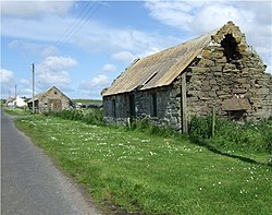
 Abandoned buildings at Sarclet | |
| Location | |
| Grid reference: | ND352435 |
| Location: | 58°22’33"N, 3°6’33"W |
| Data | |
| Post town: | Thrumster |
| Postcode: | KW1 5 |
| Local Government | |
| Council: | Highland |
| Parliamentary constituency: |
Caithness, Sutherland and Easter Ross |
Sarclet is a remote, clifftop crofting township on the east coast of Caithness, sitting to the north of Loch Sarclet.
Sarclet Head, half a mile southeast of the township, extends into the sea. Sarclet has a natural harbour called The Haven which was formerly used by fishing boats, but is now largely unused.
The village of Thrumster stands half a mile to the north-west, and the county town, Wick, is five miles north of Sarclet.