Chances Peak: Difference between revisions
Created page with '{{Infobox hill |name=Chances Peak |county=Montserrat |range= Soufrière Hills |picture= Soufriere Hills.jpg |picture caption=Chances Peak |height=3,002 feet (varies) |latitude=16…' |
No edit summary |
||
| (One intermediate revision by the same user not shown) | |||
| Line 3: | Line 3: | ||
|county=Montserrat | |county=Montserrat | ||
|range= Soufrière Hills | |range= Soufrière Hills | ||
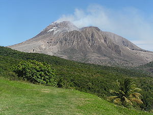
|picture= Soufriere Hills.jpg | |picture=Soufriere Hills.jpg | ||
|picture caption=Chances Peak | |picture caption=Chances Peak | ||
|height=3,002 feet (varies) | |height=3,002 feet (varies) | ||
|latitude= | |latitude=16.711 | ||
|longitude= | |longitude=-62.1772 | ||
}} | }} | ||
'''Chances Peak''' on [[Montserrat]] is the culminant point of the active complex stratovolcano named [[Soufrière Hills]]. It is the highest point of the island and [[British overseas territory|territory]]. | '''Chances Peak''' on [[Montserrat]] is the culminant point of the active complex stratovolcano named [[Soufrière Hills]]. It is the highest point of the island and [[British overseas territory|territory]]. | ||
| Line 18: | Line 18: | ||
==Outside links== | ==Outside links== | ||
[[File: | [[File:Soufriere Hills Volcano.jpg|right|thumb|200px|The Soufrière Hills smoking]] | ||
*[http://www.mvo.ms/ Montserrat Volcano Observatory (MVO)] - Current monitoring of the Soufrière Hills Volcano in [[Montserrat]]. | *[http://www.mvo.ms/ Montserrat Volcano Observatory (MVO)] - Current monitoring of the Soufrière Hills Volcano in [[Montserrat]]. | ||
*[http://vulcan.wr.usgs.gov/Volcanoes/WestIndies/Montserrat/framework.html USGS Info on Soufrière Hills Volcano] | *[http://vulcan.wr.usgs.gov/Volcanoes/WestIndies/Montserrat/framework.html USGS Info on Soufrière Hills Volcano] | ||
Latest revision as of 23:18, 13 December 2015
| Chances Peak | |||
| Montserrat | |||
|---|---|---|---|
 Chances Peak | |||
| Range: | Soufrière Hills | ||
| Summit: | 3,002 feet (varies) 16°42’40"N, 62°10’38"W | ||
Chances Peak on Montserrat is the culminant point of the active complex stratovolcano named Soufrière Hills. It is the highest point of the island and territory.
The height of Chances Peak is usually given as 3,002 feet, but the lava dome in English's Crater varies; in 2006 for example it was measured at 3,051 feet but there have been several eruptions since then, the latest in 2012.
On 17 September 1965 a Boeing 707 aircraft operating as Pan Am Flight 292 flew into Chances Peak near the summit and was destroyed, killing the 30 people on board.[1]
Eruptions have been frequent since 1995 when the volcano awoke from its dormant state. In 1997 a major eruption devastated the southern part of the island and buried the capital, Plymouth. Agricultural land was destroyed, villages were flattened and 19 people were killed. The crisis prompted more than half of the island's population to leave; those who stayed were evacuated to the north. The restless volcano has prevented their return.
Outside links

- Montserrat Volcano Observatory (MVO) - Current monitoring of the Soufrière Hills Volcano in Montserrat.
- USGS Info on Soufrière Hills Volcano
- British Geological Survey
References
- ↑ Aviation Safety Network N708PA accident synopsis retrieved 2010-06-14