Annaghone: Difference between revisions
Jump to navigation
Jump to search
Created page with "{{Infobox townland |name=Annaghone |county=Tyrone |picture=Annaghone Townland - geograph.org.uk - 274434.jpg |os grid ref=H8473 }} '''Annaghone''' is a townland in Tyron..." |
No edit summary |
||
| Line 4: | Line 4: | ||
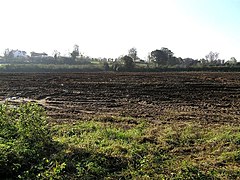
|picture=Annaghone Townland - geograph.org.uk - 274434.jpg | |picture=Annaghone Townland - geograph.org.uk - 274434.jpg | ||
|os grid ref=H8473 | |os grid ref=H8473 | ||
|LG district=Cookstown | |||
}} | }} | ||
'''Annaghone''' is a [[townland]] in [[Tyrone]], found between [[Cookstown]] and [[Stewartstown]]. There are just a few houses in the townland, along a minor lane toward the latter village. | '''Annaghone''' is a [[townland]] in [[Tyrone]], found between [[Cookstown]] and [[Stewartstown]]. There are just a few houses in the townland, along a minor lane toward the latter village. | ||
Latest revision as of 19:54, 4 September 2014
| Annaghone TOWNLAND | |
| Tyrone | |
|---|---|

| |
| Location | |
| Grid reference: | H8473 |
| Data | |
Annaghone is a townland in Tyrone, found between Cookstown and Stewartstown. There are just a few houses in the townland, along a minor lane toward the latter village.
Annaghone claims to be the geographical centre of Northern Ireland.
