Westport, Somerset: Difference between revisions
Jump to navigation
Jump to search
Created page with '{{Infobox town |name=Westport |county=Somerset |picture=The Old Gospel Hall Westport - geograph.org.uk - 476115.jpg |picture caption=The Old Gospel Hall, Westport |os grid ref=ST…' |
(No difference)
|
Latest revision as of 22:51, 23 May 2014
| Westport | |
| Somerset | |
|---|---|
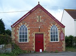
 The Old Gospel Hall, Westport | |
| Location | |
| Grid reference: | ST387201 |
| Location: | 50°58’40"N, 2°52’24"W |
| Data | |
| Postcode: | TA10 |
| Dialling code: | 01460 |
| Local Government | |
| Council: | South Somerset |
| Parliamentary constituency: |
Somerton and Frome |
Westport is a village in Somerset, close to the edge of the Somerset Levels, less than a mile south of Hambridge, with which it shares a civil parish.
The village lies along the disused Westport Canal, which joins the River Isle to the north near Hambridge. The twoi villages of Westport and Hambridge together had a recorded population of 514 in 2011.
The two villages, Hambridge and Westport, share many resources including Parish Council, Church, Branch of the Royal British Legion and Recreation Trust who manage a well maintained recreation ground and Village Hall.
Outside links
| ("Wikimedia Commons" has material about and Westport Hambridge and Westport) |
References

