Dingwall: Difference between revisions
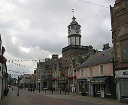
Created page with '{{Infobox town | name= Dingwall | gaelic= Inbhir Pheofharain | county = Ross-shire | picture=Dingwall - geograph.org.uk - 36070.jpg | picture caption=Dingwall | population = 5,0…' |
|||
| (One intermediate revision by one other user not shown) | |||
| Line 16: | Line 16: | ||
| dialling code= 01349 | | dialling code= 01349 | ||
}} | }} | ||
'''Dingwall''' is the county town of [[Ross-shire]]. Dingwall, a royal burgh, stands near the coast of [[Easter Ross]], by the head of the [[Cromarty Firth]] where the valley of the [[River Peffery]] unites with the alluvial lands at the mouth of the Conon, 14 miles northwest of [[Inverness]] It was once an east-coast port, before the sea receded and left it inland. | '''Dingwall''' is the county town of [[Ross-shire]]. Dingwall, a royal burgh, stands near the coast of [[Easter Ross]], by the head of the [[Cromarty Firth]] where the valley of the [[River Peffery]] unites with the alluvial lands at the mouth of the Conon, 14 miles northwest of [[Inverness]] It was once an east-coast port, before the sea receded and left it inland. | ||
The town holds the shortest and most northerly canal in the United Kingdom, the [[Dingwall Canal]]. It is more comprehensively connected by the A9 road and by rail by the Far North Line and the Kyle of Lochalsh Line, for which Dingwall serves as the junction. Dingwall Station is served by some 26 trains a day, 14 of which go to Inverness. | The town holds the shortest and most northerly canal in the United Kingdom, the [[Dingwall Canal]]. It is more comprehensively connected by the A9 road and by rail by the Far North Line and the Kyle of Lochalsh Line, for which Dingwall serves as the junction. Dingwall Station is served by some 26 trains a day, 14 of which go to Inverness. | ||
The town is home | The town is home to the Highland Theological College, recently approved for the training of [[Church of Scotland]] ministers. | ||
==History== | ==History== | ||
| Line 53: | Line 52: | ||
* [http://www.reidshighlandfare.co.uk/ Outside Catering in Dingwall area] | * [http://www.reidshighlandfare.co.uk/ Outside Catering in Dingwall area] | ||
* [http://www.tullochcastle.co.uk/ Tulloch Castle] | * [http://www.tullochcastle.co.uk/ Tulloch Castle] | ||
[[Category:Þingvellir place-names]] | |||
Latest revision as of 21:50, 23 June 2013
| Dingwall Gaelic: Inbhir Pheofharain | |
| Ross-shire | |
|---|---|
 Dingwall | |
| Location | |
| Grid reference: | NH550587 |
| Location: | 57°35’44"N, 4°25’34"W |
| Data | |
| Population: | 5,026 (2001) |
| Post town: | Dingwall |
| Postcode: | IV15 |
| Dialling code: | 01349 |
| Local Government | |
| Council: | Highland Council |
| Parliamentary constituency: |
Ross, Skye and Lochaber |
Dingwall is the county town of Ross-shire. Dingwall, a royal burgh, stands near the coast of Easter Ross, by the head of the Cromarty Firth where the valley of the River Peffery unites with the alluvial lands at the mouth of the Conon, 14 miles northwest of Inverness It was once an east-coast port, before the sea receded and left it inland.
The town holds the shortest and most northerly canal in the United Kingdom, the Dingwall Canal. It is more comprehensively connected by the A9 road and by rail by the Far North Line and the Kyle of Lochalsh Line, for which Dingwall serves as the junction. Dingwall Station is served by some 26 trains a day, 14 of which go to Inverness.
The town is home to the Highland Theological College, recently approved for the training of Church of Scotland ministers.
History
King Alexander II created Dingwall a royal burgh in 1226, and James IV renewed its charter. On the top of Knockfarrel, a hill about three miles to the west, stands a large and very complete vitrified fort with ramparts.
In 1411 the Battle of Dingwall is said to have taken place between the Clan Mackay and the Clan Donald.
In late October 2006, Dingwall suffered widespread flooding during storms, during which the weather cut off much of the Highlands north of Inverness, including the A9 and the Far North Line for a significant period of time.[1]
The town's name

The name "Dingwall" is derived from the Norse Þingvöllr (field or meeting-place of the thing, or local assembly. Similar names are found in a number of places, notably Tynwald Hill on the Isle of Man, Thingwall in Cheshire, Tingwall in Orkney and in Shetland too, and most famously the Þingvellir in Iceland.[2].
Gaels call the town Inbhir Pheofharain meaning "the mouth of the Peffery".
Sights of the town

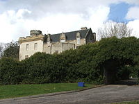
Dingwall Castle was once the biggest castle north of Stirling. Tulloch Castle stands on the town's present-day outskirts, parts of which may date back to the 12th-century building.
The 18th-century town house of the Earls of Ross stands in the town, and some remains of the ancient mansion of Earls from the height of their power.
An obelisk 51 feet high was erected over the grave of Sir George Mackenzie, 1st Earl of Cromartie, near the parish church of St Clement. It was affected by subsidence, becoming known as the "Leaning Tower", and was replaced by a much smaller replica in the early years of the 20th century. However even this is now marked by signs saying "Keep Out" on the grounds that it is a dangerous structure.