Black Hill, Malvern: Difference between revisions
Created page with '{{Infobox hill |name=Black Hill |county 1=Herefordshire |county 2=Worcestershire |range=Malvern Hills |picture=Black Hill from Pinnacle Hill - geograph.org.uk - 503911.jpg |heigh…' |
No edit summary |
||
| Line 6: | Line 6: | ||
|picture=Black Hill from Pinnacle Hill - geograph.org.uk - 503911.jpg | |picture=Black Hill from Pinnacle Hill - geograph.org.uk - 503911.jpg | ||
|height=1,010 feet | |height=1,010 feet | ||
|latitude=52.0682 | |||
|longitude=-2.3384 | |||
|os grid ref=SO768412 | |os grid ref=SO768412 | ||
}} | }} | ||
'''Black Hill''' is in the middle part of the [[Malvern Hills]], the | '''Black Hill''' is in the middle part of the [[Malvern Hills]], the eight-mile ridge which here marks the border of [[Herefordshire]] with [[Worcestershire]]. Black Hill's twin summits are both on the border, and of these the north top reaches 1,010 feet above sea level, while the south top is at 840 feet. | ||
Black Hill is to the south of [[Pinnacle Hill]] and north of the pass by which the A449 breaks across the ridge of the hills. It is a long, narrow hill, in common with most of the Malvern Hills. Quarrying has carved a piece out of its south-eastern slope of the north top, by quarrying has long since ceased, allowing the hill to be a bracingly peaceful place. | Black Hill is to the south of [[Pinnacle Hill]] and north of the pass by which the A449 breaks across the ridge of the hills. It is a long, narrow hill, in common with most of the Malvern Hills. Quarrying has carved a piece out of its south-eastern slope of the north top, by quarrying has long since ceased, allowing the hill to be a bracingly peaceful place. | ||
Latest revision as of 16:50, 28 June 2024
| Black Hill | |||
| Herefordshire, Worcestershire | |||
|---|---|---|---|

| |||
| Range: | Malvern Hills | ||
| Summit: | 1,010 feet SO768412 52°4’6"N, 2°20’18"W | ||
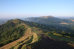
Black Hill is in the middle part of the Malvern Hills, the eight-mile ridge which here marks the border of Herefordshire with Worcestershire. Black Hill's twin summits are both on the border, and of these the north top reaches 1,010 feet above sea level, while the south top is at 840 feet.
Black Hill is to the south of Pinnacle Hill and north of the pass by which the A449 breaks across the ridge of the hills. It is a long, narrow hill, in common with most of the Malvern Hills. Quarrying has carved a piece out of its south-eastern slope of the north top, by quarrying has long since ceased, allowing the hill to be a bracingly peaceful place.
The Shire Ditch runs along the top ridge of the hill, and joins not only the two tops on Black Hill but runs on along the hills to the north all the way to the Worcestershire Beacon.
North Top
The North Top is the higher of Black Hill's summits, at 1,010 feet.
South Top
The South Top, at 840 feet, is the lower of the two but perhaps the more visited. The Worcestershoire Way runs up to the South Top from Little Malvern and down again to the road to Malvern Wells.