Thatcham
| Thatcham | |
| Berkshire | |
|---|---|
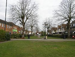
 The Broadway | |
| Location | |
| Grid reference: | SU511676 |
| Location: | 51°24’18"N, 1°15’52"W |
| Data | |
| Population: | 22,824 (2001) |
| Post town: | Thatcham |
| Postcode: | RG18 and RG19 |
| Dialling code: | 01635 |
| Local Government | |
| Council: | West Berkshire |
| Parliamentary constituency: |
Newbury |
Thatcham is a modest town in Berkshire, found 3 miles east of Newbury and 15 miles west of Reading. A town of about 23,000 souls (estimated in 2003), has expanded rapidly with new developments: the opopulation was just 5,000 in 1951.
Thatcham stands on the River Kennet and on the Kennet and Avon Canal. The A4 road passes through and the course of a Roman road. It is also served by the railway to London.
Parish church
The parish church is St Mary's. It is a largely Norman church which was largely reconstructed in 1857. The church is locally believed to be built on the same site as an earlier Saxon church.
Though the church is now known as St Mary's, it also formerly bore the name St Luke's.
History
The area has evidence of occupation dating from prehistoric times[1] and is listed in the Guinness Book of Records as the strongest claimant to being the oldest continuously inhabited place in Britain. The well-preserved remains of a Mesolithic settlement dating from 7,700 BC[2] have been found in its vicinity. There is also evidence of Bronze Age and Iron Age settlements and of a Roman town.
The town had a period of great prosperity around 1304[3] when the Chapel of St Thomas the Martyr was built, where the A4 now runs. The chapel was converted into a school at the Reformation and is now The Old Bluecoat School. In the early fourteenth century the population was larger than Newbury's but declined as a result of the Black Death which devastated the area in 1348.
In 1121 King Henry I founded the great Abbey of Reading and endowed it with many gifts of land, including the Manor of Thatcham. At the same time Thatcham Hundred was divided, the western part transferred to Farcross Hundred, and the remainder to the Hundred of Reading.
In 1141 Thatcham Church, previously the property of the Diocese of Salisbury, was granted to Reading Abbey by the Empress Mathilda, who at the same time confirmed her father's gift of the manor to the Abbey.
A large area of Thatcham, including the manors of the borough and Colthrop, was bought by Brigadier-General Waring from James, Duke of Chandos in 1722. Waring subsequently built Dunstan House, to the north of Thatcham village, and enclosed a large park around it, planted with trees arranged in the troop positions in the battles in which he had fought. When his descendants put his estates up for auction in 1798, Dunstan House failed to sell and was pulled down. The land is now a housing estate called Dunstan Park.
Two mills were built at Colthrop in 1472, one for corn and one for fulling. The latter was probably converted after the decline of the cloth trade. These mills were replaced by a paper mill built on their site by 1799. This Colthrop Mill belonged to the Reed Group in the twentieth century, and produced packaging materials.[4]
The Kennet and Avon Canal was dug through here in the eighteenth century. Monkey Marsh Lock, built in 1723, is one of only two turf-sided locks on the Kennet and Avon Canal.
Since 1900, industry has been attracted to the area. The Colthrop Board Mills (closed down in 2000), where paper had been produced for over 200 years, grew very quickly, particularly after its acquisition by the worldwide Reed Paper Group. The Sterling Cable Works was established nearby and AWE Aldermaston and AERE Harwell, together with the RLC Depot at Station Road, (which closed down in 1999) have all brought employment and increasing prosperity to the area. This growth has in turn brought a further influx of population and has attracted numerous businesses to the town.
The development of industrial sites on the eastern side of the town introduced nationally known names such as Sony, B.O.C. Transhield, Thermalite, Panasonic and The AA Operations Centre to Thatcham. (All with the exception of Thermalite have now left the area)
Town centre facilities were enhanced in 1997 when a town centre improvement scheme was carried out in the Broadway and the High Street. Shopping facilities include two supermarkets in the town centre and associated smaller retail outlets in arcades which supplement businesses already established in the town.[5]
On 20 July 2007, parts of Thatcham were flooded during a period of sustained heavy rain, during which 3 times the average July monthly rainfall hit the town in just 24 hours. While the rivers did not burst, the quantity of water flowing down the hills from Cold Ash and Bucklebury made many roads impassable and stranded hundreds of pupils at Kennet School who tried to wade with rope across Stoney Lane. Approximately 1100 properties were affected in this period, with many residents being forced to move out into mobile homes.[6]
Geography
Thatcham lies three miles east of Newbury. The Great Bath Road (now the A4), the Great Western Railway line, the river Kennet and the Kennet and Avon Canal all cross the parish from east to west. Thatcham railway station lies to the south of the town.
The River Lambourn joins the Kennet in the west of the parish near Ham Mill. The River Enborne forms part of the southern border of the parish.[7]
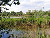
To the south of Thatcham are the Thatcham Reed Beds, denoted as a "Site of Special Scientific Interest" in 1974 as important for its extensive reedbed, species rich alder woodland and fen habitats. The latter supports Desmoulin's whorl snail (Vertigo moulinsiana), which is of national and European importance. A large assemblage of breeding birds including nationally rare species such as Cetti's Warbler (Cettia cetti) is also associated with the reedbed, fen and open water habitats found at Thatcham Reed Beds.[8]
A local attraction is The Nature Discovery Centre situated at Thatcham Lake, a flooded gravel quarry near to the Thatcham Reed Beds. The Nature Discovery Centre opened in 1995 and currently attracts over 75,000 visitors each year. A further estimated 75,000 visitors use the surrounding site for recreational activities throughout the year. There are a number of paths, a wooden sculpture trail and bird hide. The Visitor Centre has a café and offers an extensive programme of events.[9]
Economy
To many people in the UK, the name "Thatcham" is most strongly associated with the approval ratings for car security systems issued by the Motor Insurance Repair Research Centre near the town. For instance, "Thatcham Cat 1" (or just "Cat 1" is the approval for a combined car alarm and immobiliser, "Thatcham Cat 2" is for a standalone immobiliser and "Thatcham Cat 3" is for additional physical security devices such as steering wheel locks.
Sport
- Cricket: Thatcham Town Cricket Club. The first recorded match was Gentlemen of Thatcham and The Gentlemen of Aldermaston being played at Thatcham Marsh on 19 July 1786.[10]
- Football: Thatcham Town FC, founded in 1894. Their home ground is Waterside Park next to the Kennet.
Henwick Worthy Sports Ground sports ground is on the A4 in West Thatcham. There are outdoor facilities including 11 grass pitches for football and rugby, 2 cricket pitches, an artificial pitch, 3 tennis courts and 2 netball, a basketball court and children's play area. 14 changing rooms are available. Newbury and Thatcham Hockey Clubhouse is based at the sports ground and its clubhouse is situated there.[11]
Outside links
| ("Wikimedia Commons" has material about Thatcham) |
References
- ↑ "Thatcham: An historic town in a changing world". Thatcham Historical Society. http://thatchamhistoricalsociety.org.uk/events/2009/thatcham-historic-town-changing-world. Retrieved 21 February 2012.
- ↑ [thatchamhistoricalsociety.org.uk "Thatcham Historical Society"]. Thatcham Historical Society. thatchamhistoricalsociety.org.uk. Retrieved 21 February 2012.
- ↑ Thatcham Historical Society
- ↑ "Thatcham History". Berkshire Family History Society. http://www.berksfhs.org.uk/cms/Berkshire-Places/thatcham/Thatcham-contd.html. Retrieved 2012-01-12.
- ↑ "Thatcham Today". Thatcham Town Council. http://www.thatchamtowncouncil.gov.uk/public/page.php?section=history&table=info&category=today. Retrieved 2012-01-12.
- ↑ http://www.thatchamtowncouncil.gov.uk/documents/info/Briefing_note_Flooding_and_Thatcham_090209.pdf
- ↑ "Thatcham Location". Berkshire Family History Society. http://www.berksfhs.org.uk/cms/Berkshire-Places/thatcham.html. Retrieved 2012-01-12.
- ↑ "Thatcham Reed Beds". English Nature. http://www.english-nature.org.uk/citation/citation_photo/1002762.pdf. Retrieved 2012-01-12.
- ↑ "Thatcham Tourist Information". TourUK. http://www.touruk.co.uk/berkshire/Thatcham.htm. Retrieved 2012-01-12.
- ↑ "A Potted Historye". Thatcham Town Cricket Club. http://www.thatchamtowncc.co.uk/history/default.aspx. Retrieved 2012-01-12.
- ↑ "Henwick Worthy Sports Ground". Thatcham Town Council. http://www.thatchamtowncouncil.gov.uk/public/page.php?section=amenities&table=info&category=sports&record=164. Retrieved 2012-01-12.


