Salcombe
| Salcombe | |
| Devon | |
|---|---|
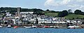
 Salcombe waterfront | |
| Location | |
| Grid reference: | SX7339 |
| Location: | 50°14’13"N, 3°46’55"W |
| Data | |
| Population: | 1,893 (2001) |
| Post town: | Salcombe |
| Postcode: | TQ |
| Dialling code: | 01548 |
| Local Government | |
| Council: | South Hams |
| Parliamentary constituency: |
Totnes |
Salcombe is a little maritime town in the very south of Devon, close to the mouth of the Kingsbridge Estuary and climbing up the steep slopes on the steep west side of the estuary.
The town's extensive waterfront and the naturally sheltered harbour formed by the estuary have enured that Salcombe has long been a town tied to the sea, and has found success in boatbuilding and shipbuilding. These days it is popular with sailing enthusiasts and is a tourist destination. A great deal of pleasure sailing and yachting takes place here. There is also a crabbing industry.
Salcombe is within the South Devon "Area of Outstanding Natural Beauty".
Contents
History
There are a number of shipwrecks off Salcombe. One is of a Bronze Age ship, one of only three known in Britain, which had French made weapons and jewellery. The Salcombe Cannon Wreck is of a 17th-century ship that contained 400 Moroccan gold coins and Dutch items. In 1936 a Finnish four-masted barque, Herzogin Cecilie stranded at Bolt Head. Also off Salcombe is HMS Untiring which is a Second World War submarine that was sunk in 1957 as a sonar target.
A description of the South Hams is given in the 9th century charter S298. This does not show Salcombe but its area is part of Badestone (Batson).[1] "Salcombe" first appears in the records in 1244, on the boundaries of Batson and West Portlemouth. In 1570, there were 56 mariners while two years later another survey shows five ships under 60 tons at Salcombe.
In 1566 there were ten seine nets at Salcombe while in the 1580s Salcombe fishermen travelled to Padstow annually for the new herring fishery. While there they rented cottages and storehouses.[2]
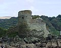
During the English civil war the town sided with the Royalists and held out against the Roundheads. The ruins of Fort Charles remain towards the south of the town. It held out from January to May 1646 and was the last Royalist stronghold. This fort was built for Henry VIII to defend the estuary. It was slighted on the orders of Parliament after the Civil War.
There is little record of the town between 1650 and 1750, but it is thought that the inhabitants lived by fishing and smuggling.[3] In 1764, the first holiday home, The Moult, was built in Salcombe.

In the 19th century, Salcombe was a major centre for shipping in the fruit trade. Salcombe vessels sailed to Iberia, the Mediterranean and the Caribbean as well as to the Azores and Newfoundland. The fruit cargoes were oranges and lemons from the Azores, and pineapples from the Bahamas and West Indies. Other cargoes brought back included sugar, rum, coconuts and shaddocks. In addition wood such as ebony and mahogany was brought for furnishing ships. Salcombe and Kingsbridge were busy ship building places, producing the Salcombe schooner. This was a fast boat that could be sailed with few hands. However, almost half the fleet were lost with all hands. A mutual marine assurance association had been established in 1811 to insure Salcombe ships.
The Salcombe fleet also was involved in the coastal trade supplying coal from Wales and taking away cider, malt, grain and slates. A ferry to Brest was set up in 1870 but did not last.
By 1871, the central part of Salcombe, excluding the outlying districts, numbered 776 people, with 34 shipwrights and 13 ships carpenters. There were also five sawyers, three block makers, two ship's riggers, three sail makers, a tin plate worker and four blacksmiths. However, in the 1870s the fruit trade declined due to outbreaks of orange and pineapple disease and because of the advent of steamships. Some work was found taking salt to Newfoundland and returning with cod but by 1914 there were only three or four locally owned trading ships in the estuary. At this time there was the start of pleasure sailing at Salcombe with the yacht club being founded in 1874. One of the boats raced was the Salcombe yawl for which an owner's association has been set up.
Salcombe became a ship registry port in 1864, but still came under Dartmouth for customs. A customs house was later built at Salcombe which still exists. Between 1796 and 1887 at least 200 vessels were launched from Salcombe. To have more space the shipyards were extended by reclaiming the foreshore. These were later built over and new ones made in Shadycombe Creek. However, many vessels were lost, including seven local boats off the Azores in November 1851. There were four sailmakers lofts at Salcombe and three shipsmiths in 1851. The majority of the Victorian houses seen in Salcombe today were built by shipowners and masters. After 1880, with the advent of steam propulsion and larger ships, there was less new construction and repair work. Salcombe's seamen and craftsmen moved to the deep sea fishing ports or to the dockyards.[4]
A turnpike road was built to Salcombe in 1824.[5] Originally Salcombe was part of Malborough parish but a chapel-of-ease was built at Salcombe in 1401. The parish church was not built until the 19th century. The population of Salcombe was 972 in 1841, but had risen to about 1500 by 1850. There is also a Wesleyan Chapel and a Roman Catholic church.
Between the two world wars Salcombe developed as a holiday resort, with Salcombe Sailing Club being founded in 1922.
During the Second World War a radar station was set up on Bolt Head and Salcombe became an Advance Amphibious Base for the United States Navy in September 1943. The Salcombe Hotel became the latter's headquarters and 60 other properties were requistioned, as well as Quonset huts being built on the hill near the Rugby Club. Whitestrand Quay and slipway was constructed. 137 officers and 1793 men were based at Salcombe. 66 ships and many auxiliary vessels sailed from Salcombe on 4 June 1944 as part of "Force U" which landed on Utah Beach, Normandy. Afterwards Shadycombe Creek and Mill Bay were used to repair damaged landing craft. The base closed on 7 May 1945. A plaque was set up in Normandy Way to commemorate the United States Navy.[6] Salcombe and district suffered a number of bombing raids during the war and a list of the casualties is available online.[7]
The former radar station at Bolt Head near Salcombe was set up to be used as the Regional Seat of Government in the event of attack during the Cold War. This has subsequently been dismantled.
There have been many changes to the Salcombe Waterfront since Second World War, the most noticeable being the construction of the Creek car and boat park, and the road to Batson.[8] Salcombe became an urban district following an Act of Parliament in 1972.
One of the most extraordinary cases in British criminal history took place in Salcombe. John Allen (originally Anthony John Angel) was convicted of murdering his wife Patricia and their two children 27 years after the event. They disappeared without trace in May 1975 and were never found. He claimed that she had walked out on him but his ex-lover, Eunice Yabsley, later claimed that she had seen scratches on his forearms. After falling out with him, she wrote a book "Presumed Dead" in 1992 and the police re-investigated the case. John Allen was convicted in December 2002.
Estuary

Salcombe and Kingsbridge estuary lies between Bolt Head and Sharpitor on the west and Portlemouth Down on the east, and runs inland for some 4 miles, with numerous side channels. The "estuary" is technically known as a "ria" or drowned valley caused by rising sea levels.
The estuary is a vast creek transformed with the tide; at the flood the creek is a full, broad waterway, but at low tide broad, shining mudflats fill it, leaving Salcombe afloat but much of the creek mud.
Bar and RNLI lifeboat
Towards the mouth of the estuary is the Bar, a spit of sand protruding from the east bank which is exposed at low spring tides. In this state of tide and with strong southerly winds the bar can make the entrance to the estuary nearly impassable.
It is believed that Lord Tennyson's famous poem "Crossing the Bar" was inspired by a visit to Salcombe during the 19th century. The poem begins with the lines:
| “ | Sunset and evening star and one clear call for me! And may there be no moaning of the bar, When I put out to sea |
” |
The moaning refers to the noise of the water breaking over The Bar.
Salcombe Lifeboat Station was established by the Royal National Lifeboat Institution in 1869. In 1916 the Salcombe lifeboat, an open rowboat "The William and Emma", was capsized crossing The Bar resulting in 13 of the 15 crew's lives being lost. However another crew was soon formed and the station continues to this day. The original lifeboat station on South Sands is no longer used and there is a lifeboat museum and shop in Salcombe town, at the lifeboat station itself.[9]
Beaches

Further into the estuary on the east side are a series of popular sandy beaches: Sunny Cove (nearest the bar), the large Mill Bay, Cable Cove (the landing point of a cross-channel cable),[10] Small's Cove and Fisherman's Cove. Adjacent to Fisherman's Cove is a landing slip used by the ferry — open-topped clinker-built motorboats — from Salcombe directly across the estuary, communicating with the hamlet of East Portlemouth (and much used by tourists for access to the beaches).
Opposite the Bar on the west side of the estuary are the beaches of South Sands and North Sands. A picturesque ferry operates between Salcombe and South Sands, with a Sea Tractor ferrying passengers between the boat and the South Sands beach.
North of North Sands Salcombe town begins, occupying the steep west side of the estuary opposite the beaches and East Portlemouth and extending north and west into the first of the estuary's many creeks: Batson Creek by Snapes Point. Others, including Southpool Creek and Frogmore Creek, branch off to the east and north east, while the main channel continues to Kingsbridge itself. A larger boat operates in the summer as a ferry between Salcombe and Kingsbridge when the state of the tide permits. Salcombe now also has spread down the west side of The Berry below the main road to Malborough.
Sailing
Sailing in Salcombe is active, day sailors go out from the harbour or from up the river. Many people own boats, power and sail, in the area and is the reason that many of the tourists choose to go there.
Salcombe Yacht Club hosts the Salcombe Yacht Club Regatta every August, attracting up to 400 dinghies in 10 or more dinghy classes plus handicap fleets. This regatta runs consecutively with the Salcombe Town Regatta attracting a smaller entry, but covering the same range of classes.
The premier dinghy class in Salcombe is the Salcombe Yawl
Also up the river, there is the former Mersey ferry, Egremont.
Economy

Probably due to its popularity for pleasure such as sailing and yachting, Salcombe has the second highest property prices in the UK outside of central London (after Sandbanks in Dorset). Many of the shops, bars and restaurants in the town, especially towards the waterfront, cater for a predominantly well-off and nautically-inclined clientele, with prices to match. There are many clothes shops and art galleries. Salcombe has hotels and bed and breakfast establishments as well as self-contained apartments and houses.
Salcombe has a number of boatyards and marine stores, while boats are stored on the carpark by the fishing quay during the winter. There is a sailing school run by the Island Cruising Club, based on the ex-Mersey ferry "Egremont" moored in the estuary. There is also a power boat school and SCUBA diving is popular. The town and yacht club regatta weeks are one of the main features of the summer season. There are races for dingies and yachts as well as crabbers in addition to other activities. Salcombe Estuary Rowing Club is a member of the Cornish Pilot Gig Association and takes part in races around the south west.
Fishing is still carried out at Salcombe, mostly of shellfish. About 2,000 tons a year were landed between 1986 and 1990.[11]
Salcombe in literature
In The Letter of Marque by Patrick O'Brien, the port of Shelmerston appears to be based closely on Salcombe. In the novel The Surprise (by then a private man o' war) is based at Shelmerston, described as a small port avoided by the Royal Navy because of the dangerous bar. Shelmerston is a rough port full of smugglers and privateers.
Pictures

Waterfront
Salcombe showing the church
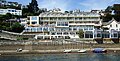
Marine Hotel
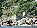
Fake gun battery
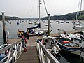
Normandy pontoon
Ruins of Fort Charles
The old lifeboat station on South Sands


Outside links
References
- ↑ Studies on Devon Charter Boundaries, D. Hooke, Trans. Devon Assoc. (1990) pp 193-211
- ↑ Historical Atlas of the South West, Kain and Ravenshill, 1999
- ↑ Salcombe Information
- ↑ Salcombe Harbour Remembered, Muriel and David Murch and Len Fairweather, 1982
- ↑ Historical Atlas of the South West
- ↑ The Armed Forces at Salcombe and Slapton during Second World War, Muriel and David Murch and Len Fairweather, 1984
- ↑ http://www.devonheritage.org
- ↑ Salcombe Harbour Remembered
- ↑ Leach, Nicholas (2009). Devon's Lifeboat Heritage. Chacewater: Twelveheads Press. pp. 21–25. ISBN 0-906294-72-X.
- ↑ History of the Atlantic Cable & Undersea Communications Cable
- ↑ Historical Atlas of the South West.