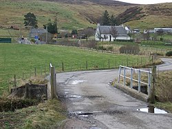
Pittentrail
| Pittentrail Gaelic: Bad an Tràill | |
| Sutherland | |
|---|---|

| |
| Location | |
| Grid reference: | NC725020 |
| Location: | 57°59’22"N, 4°9’26"W |
| Data | |
| Post town: | Rogart |
| Postcode: | IV28 3 |
| Local Government | |
| Council: | Highland |
| Parliamentary constituency: |
Caithness, Sutherland and Easter Ross |
Pittentrail is a hamlet on the A839 road, in the Rogart estate in eastern Sutherland. The River Fleet runs to the south.
The name 'Pittentrail' seems to come at least in part from the lost Pictish language: the word pett means 'farm' or a measure of land, a word which is a possible relative of Welsh peth meaning 'possession'. The 'trail' part of the name, however, is unknown in origin.
The hamlet today
The settlement became better known in the area when Rogart Station was built in the village. The station is no longer used for its original purpose, but instead, the station buildings have been converted into private residential use. The station yard has been made into gardens, with old signs and other railway memorabilia lying about. The original sidings have been retained, and the train carriages sitting on them converted into a novel independent youth hostel.[1]
The lively Pittentrail Inn is on the north side of the village, near the war memorial.
Outside links
| ("Wikimedia Commons" has material about Pittentrail) |