Newland, Kingston upon Hull
| Newland | |
| Yorkshire East Riding | |
|---|---|
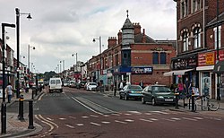
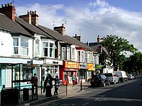
 Newland Avenue | |
| Location | |
| Grid reference: | TA086314 |
| Location: | 53°46’6"N, 0°21’14"W |
| Data | |
| Local Government | |
| Council: | Kingston upon Hull |
Newland is a village which has become a suburb of Kingston upon Hull in the East Riding of Yorkshire. It is found in the north-west of the city, having grown from a village on the Hull to Beverley turnpike.
Before the mid 18th century Newland was a hamlet in a partially swampy agricultural area, located near the crossroads of Cottingham and Beverley-Hull turnpikes. Extensive enclosure and drainage took place after 1766, and it briefly developed as a preferred place for Hull merchants in the 19th century. The future parish church, St John's, was built in 1833, and in 1862 the ecclesiastical parish of Newland was established as separate from Cottingham. By the beginning of the 20th century the urban spread of Hull had reached Newland, and over the next half century the village was surrounded by housing and other developments.
The modern area of Newland includes and the former site of the Kingston upon Hull Municipal Training College (est. 1913), now part of the neighbouring University of Hull (est. 1925), as well as the Newland Park estate, and the Newland Avenue areas.
Other notable structures in the area include the former Endsleigh convent (orig. built 1876, expanded), and former Sailor's Orphan's Homes (1890s), and the modern police headquarters (2012). The Newland area extends along Clough Road to the River Hull – east of the Cottingham/ Beverley Road crossroads, where the area is in primarily industrial and commercial use. On the banks of the Hull is a chemical works of the Croda company.
History
The Beverley-Hull road, which passed through Newland was turnpiked by an Act of Parliament in 1744, with a toll bar established at Newland, at a place called Newland Bridge. In 1764 the Act was extended in duration, with the road from Newland Bridge to Cottingham added to the trustees' responsibilities.[1]
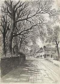
In around 1797 the area of Newlands (Newlands Tofts and Newland Fields) was described in The Gentleman's Magazine as "low and flat, but exceedingly rich pasture ground, producing plenty of milk and butter, which affords the best supply for Hull market"; in the same Newland was described as a "Neat little hamlet".[2]
An enclosure and drainage act for Cottingham was passed in 1766; the Beverley and Skidby Drain was enabled by an Act of 1785; and the Beverley and Barmston Drain was built after an enabling act of 1798. The Cottingham Drain improved the marshy land in the area. The Barmston, and the Skidby Drains were built primarily for areas beyond Newland. Three houses on the south side of Cottingham Road are remnants of the village, dating to the late 1700s.
Hull merchants migrated to Newland in the early 19th century, building large houses.[3] In 1832 a church, St John’s, was consecrated at Newland.[4]
In the mid 1850s the Newland area was almost completely rural and isolated from both Cottingham and Hull by enclosed fields. I was however expanding soon to join the townscape of Hull.
Some clay extraction took place in Newland – with a pit to the north of the village, and a substantial brick and tile works nearer the River Hull.
The Newland Park estate was established around 1877 by William Botterill on the south side of Cottingham Road. It developed slowly as a high status middle class housing estate over the next half century. Several of the houses are in an Arts and Crafts style, with a variety of architectural styles found.[5][6]
In 1885 the Hull and Barnsley Railway opened – its branch to the Alexandra Dock (now Hull Docks Branch) passed through the south of the parish, crossing Newland Avenue by a bridge.
In 1909 the Hull Corporation Trams had reached the Newland crossroads on Beverley Road, and a tram depot was established on Cottingham Road. By the mid 1920s the urban growth of Hull had extended north past Newland village.
During the Second World War an anti-aircraft battery was on the Chanterlands Avenue side of the Northern Cemetery, and there was a military camp at the junction of Beverley Road and Endike Lane
Outside links
| ("Wikimedia Commons" has material about Newland, Kingston upon Hull) |
References
- ↑ MacMahon, K. A. (1964). Roads and Turnpike Trusts in Eastern Yorkshire. East Yorkshire Local History Society. 17–20. http://www.eylhs.org.uk/dl/128/roads-and-turnpike-trusts-in-east-yorkshire. Retrieved 6 February 2016.
- ↑ Urban, Sylvanus, ed (December 1797). Topographical Description of Cottingham Near Hull. 67, 2nd part. 1003. https://books.google.com/books?id=06wUAAAAQAAJ&pg=PA1003.
- ↑ Pevsner & Neave 1995, p. 558.
- ↑ Overton, Charles (1861). The History of Cottingham. p. 108.
- ↑ Neave & Neave 2010, pp. 160–161.
- ↑ Pevsner & Neave 1995, p. 556.
- Allison, K. J., ed (1969). The City of Kingston Upon Hull. 1. http://www.british-history.ac.uk/vch/yorks/east/vol1.
- Neave, David; Neave, Susan (2010). Hull. Yale University Press. ISBN 978-0-300-14172-6.
- Pevsner, Nikolaus; Neave, David (1995). Yorkshire: York and the East Riding (2 ed.). ISBN 9780300095937.
- Sheahan, James Joseph (1864). A general and concise history and description of the town and port of Kingston-upon-Hull. Simpkin, Marshall & Co. (London), John Green (Beverley). https://archive.org/details/generalconcisehi00shea.


