Kearsley
| Kearsley | |
| Lancashire | |
|---|---|
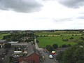
 Kearsley looking north from St Stephen's Church tower | |
| Location | |
| Grid reference: | SD755055 |
| Location: | 53°31’48"N, 2°22’12"W |
| Data | |
| Population: | 14,212 (2011) |
| Post town: | Bolton |
| Postcode: | BL4 |
| Dialling code: | 01204 |
| Local Government | |
| Council: | Bolton |
| Parliamentary constituency: |
Bolton South East |
Kearsley is a town in Lancashire: a place of 14,212 according to the 2011 census. It is to be found in the industrialised belt in the south of the county, eight miles northwest of Manchester, five miles south-west of Bury and just uner four miles south of Bolton. This is a heavily urbanised area, with townscape stretching barely broken out from Manchester, and Kearsley, though achieving a narrow green separation on three sides, is contiguous with Farnworth to the north-west, though separated from it by the A666 trunk road and motorway spur.
Kearsley was anciently a township in the parish of Deane. It was transformed by the Industrial Revolution.
History

Kearsley was industrialised by 1752 when James Brindley solved drainage problems at the Wet Earth Colliery on the borders of Kearsley and Clifton. In 1780, a mill was built at the point where the River Croal meets the River Irwell[1]
In 1830[2] it was described as:
- "Kersley, a township in the parish of Deane, Hundred of Salford, 7 miles N.W. from Manchester. Inhabitants 1,833. In this township is Kearsley Moor, an extensive common, under the surface of which there are many valuable coalmines".
In the Industrial Revolution a papermill, cotton mills, chemical works, an iron foundry, a quarry and 15 coal mines operated within its boundaries.
In the mid-19th century, the area was a busy coal mining area. Several street names such as Moss Colliery Road (in nearby Clifton) bear testimony to this. The largest coal mine was the Unity Brook Colliery. On 12 March 1878 an explosion[3] in the mine killed 43 men and boys[4] and 19 of the dead were buried at the parish church.[5] By 1900 the coal mining industry had all but disappeared.
In the late 1920s, the coal-fired Kearsley Power Station was built. It used water for cooling from the River Irwell. The power station closed, and was demolished, on 12 May 1985. The power station had a railway connection,[6] which has been removed and is now a pedestrian trail.
Economy
Today Kearsley has little industry, the one remaining mill is now a multi occupancy building housing retail and light engineering. There are three small industrial estates concerned mainly with the transport industry. They are the Europa Industrial Estate and the Fishbrook Industrial Estate on Stoneclough Road plus the Lion Industrial Estate on Moss Road.
There is a small shopping precinct and some isolated shops along Manchester Road (the A666).
Transport links
The A666 from Manchester to Bolton passes through Kearsley. Today it lies on the A666 at a point where the Kearsley Roundabout connects it and Farnworth to the M61 motorway via the Kearsley Spur link road.
Kearsley railway station is on Stoneclough Road, from where there is a service northbound to Bolton and southbound to Manchester. In 1878, the mineral railway line to Kearsley was opened, at a cost of £100.[7]
Churches

St Stephen's Church, Kearsley Moor, the parish church[8] is on Manchester Road. The church was the vision of Harrison Blair[9] who owned the chemical works at Moss Lane. The church has a graveyard which holds the remains of 19 miners killed in the Unity Brook Colliery disaster. The church was founded in 1870, erected in 1870–71 by the family of the Harrison Blair who died before it was finished. It cost £3,600 and has seating for 538 parishioners.[8] The Bishop of Manchester, Dr Fraser consecrated the church on 1 July 1871.[9]
- Church of England:
- St Stephen's
- Independent / evangelical: New Jerusalem Church on Bolton Road (founded in 1836)
- Methodist: Kearsley Mount Methodist Church, founded in 1836
- Roman Catholic: St John Fisher, founded in 1969 on Manchester Road
Pictures

Kearsley looking north, taken from St Stephen's Church tower

Kearsley looking west, taken from St Stephen's Church tower
Kearsley looking south, taken from St Stephen's Church tower
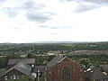
Kearsley looking east, taken from St Stephen's Church tower
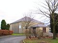
New Jerusalem church


Outside links
| ("Wikimedia Commons" has material about Kearsley) |
- Kearsley Mount Church
- St Stephens Church
- Photos and information about Kearsley
- Chairmen of Kearsley Urban District Council 1865–1974
References
- ↑ Bolton Organisation
- ↑ The New Lancashire Gazetteer or Topographical Dictionary (1830)
- ↑ This is Lancashire
- ↑ Durham Mining Museum
- ↑ Information on Kearsley from GENUKI
- ↑ Railway Byelines. 4. Irwell Valley Press. December 1998 – November 1999. pp. 226, 309.
- ↑ Bolton Revisited
- ↑ 8.0 8.1 Genuki Churches
- ↑ 9.0 9.1 St Stephen's official web site