Great Mell Fell
| Great Mell Fell | |||
| Cumberland | |||
|---|---|---|---|
 Great Mell Fell seen from Gowbarrow Fell | |||
| Range: | Lake District Eastern Fells | ||
| Summit: | 1,762 feet NY397254 54°37’12"N, 2°55’59"W | ||
Great Mell Fell is an isolated hill in Cumberland, north of Ullswater and adjacent to the amongst the Lake District's Eastern Fells. It rises from a level plain to a height of 1,762 feet and its summit is an excellent viewpoint for many of the surrounding higher fells. The fell is now owned and managed by the National Trust and offers a place of quiet refuge.
In spite of its name, the fell was once well wooded, and retains a good covering of trees on the lower slopes, as well as scattered larches and pines higher up. Its rock is unusual for the Lake District, a reddish conglomerate of Devonian age, which has been eroded to form a rounded hill with smooth outlines and no rocky crags.
Contents
Name
The hill's name is believed to have come from three languages, each adding a word: 'Mell' is from the Old Cumbric language, a sibling of Welsh, in which moel means "bare". 'Fell' is Old Norse and finally 'Great' is English. The distinction in the latter adjective is from neighbouring Little Mell Fell.
An earlier recorded form of the name is Melfel (1279) The Cumbric word has been reconstructd as męl.[1]
The two Mell Fells have been distinguished as Great and Little since at least the fifteenth century, though Greenwood's map of 1823 distinguishes them as West and East Mell Fell.[1]
Landscape
Great Mell Fell is an isolated hill which rises abruptly from a wide expanse of marshy lowland to a height of 1,762 feet. It has smooth, rounded outlines with no crags. Rock is represented only by a number of large erratic boulders, mainly on the north slopes, but also by the Cloven Stone near a barn to the south of the fell.[2]
The hill is triangular in plan (indeed, it is almost the shape of a broad arrow-head) with the apex pointing west, down the steep "nose" of the fell, and with the gentler, broader eastern slopes divided by two shallow valleys which drain into the Wham Sike and Routing Gill Beck.
Great Mell stands on the watershed between the Derwent river system to the west and the Eden system to the east. This watershed is formed by a low ridge, barely perceptible in places, which connects the Northern and Eastern Fells. From Bowscale Fell it runs across Eycott Hill to Great Mell Fell, then over Cockley Moor to High Brow and up the north-east ridge of Great Dodd, to join the main ridge on the Helvellyn Range. Thus the eastern sides of the fell drain eventually into the River Eden by way of Dacre Beck and the River Eamont, while the western parts drain through Keswick by way of Trout Beck, the River Glenderamackin and the River Greta to the Derwent.
Plantlife and wildlife
Great Mell Fell is a quiet place of refuge within the surrounding agricultural land, for wildlife as well as for walkers. The sheltered lower eastern slopes are well covered by mixed woods of oak, rowan, birch, holly and Scots pine. Within the trees badgers and roe deer live, and green woodpeckers nest.[3]:164 It is said that the last wild cat in Cumberland was snared here in the nineteenth century.[2]
Higher up the fell an old planting of Scots pine straddles the eastern ridge, and contorted wind-blown larches grow higher still, some blown almost horizontal. The trees give a glimpse of what other fells may have looked like in better-wooded times.[2] A nineteenth-century guidebook claims that larch was planted all over the fell.[4] However the fell's name suggests that it was treeless in first millennium Celtic-speaking times.
Clumps of tough grass and occasional clumps of heather cover the highest parts, where occasional red grouse may nest.[2]
Summit
The summit is crowned by a low mound, marked as a tumulus maps. This is probably a small Bronze Age burial mound. A small cairn has been built on top of it,[2] but was not there in the 1950s, when a dead tree trunk marked the spot.[5]
The isolated position of the fell makes it a splendid viewpoint. Blencathra and the Dodds dominate the view towards the west, while to the south is an impressive vista of both the Far Eastern and the Eastern Fells, as far as Red Screes and the Kirkstone Pass. To the east, beyond Little Mell Fell there is a clear view across the Eden Valley to the north Pennines.[2] [5]
Ascents
Great Mell Fell is now owned and managed by the National Trust. The whole fell is now Open Access land.
Access to the fell may be gained from near Brownrigg Farm on the minor road between Matterdale End and the A66 road, or from just south of Troutbeck on the A5091 road, along the disused rifle range. Paths just inside the boundary fence allow a circuit of the fell. The western end of the fell offers a very steep but grassy climb to the top. A gentler ascent follows a used path from the south-eastern corner and along the east ridge.[2]
History
There is a disused rifle range to the north-west of the fell. The target control building may still be seen.[2] This was in use by the War Department during the war years and into the 1950s. As a result, access to the whole fell was prohibited at the time by red danger signs. Alfred Wainwright includes a drawing of one of the signs in his 1955 guide book, but he himself apparently ignored the warnings and explored the fell anyway.[5]
Geology

Great and Little Mell Fells grouped together are unique among the fells of the Lake District by being composed of the Mell Fell Conglomerate, a sedimentary rock formed from deposits of sand and gravel in alluvial fans and braided river channels in a desert environment. The rock contains no fossils. The stones in the conglomerate came from the erosion of both the Borrowdale Volcanic Group and the Windermere Supergroup. The reddish-coloured rock appears to date from the late Devonian Period, sometime around 375 million years ago.[6] The erosion of this conglomerate has formed the smooth and rounded outlines that are distinctive of the two Mell Fells. While there are no crags on Great Mell Fell, boulders of the conglomerate may be seen in places, especially on the north slope, and it may also be seen in the two stream beds.
This Devonian conglomerate rests on the Birker Fell Andesite Formation, a thick sequence of andesite lava flows from the Ordovician Period, about 450 million years ago, and part of the Borrowdale Volcanic Group. This rock may be seen at the foot of the fell in the south-east corner, where a small quarry (at the beginning of the path along the south side of the fell) has extracted a little of this andesite.[7][8]
Rocks of the Devonian Period are also referred to as the Old Red Sandstone. These should be distinguished from the younger New Red Sandstone of the Permian Period, found nearby in Penrith and the Eden Valley.
Pictures

Great Mell Fell from the track alongside the old rifle-range

The wooded east slope of Great Mell Fell, with Little Mell Fell beyond

Routing Gill Beck on Great Mell Fell

Larch and pine trees on the top of the east ridge of Great Mell Fell
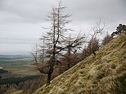
Larch tree on the steep west slope of Great Mell Fell
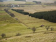
Disused rifle-range beneath Great Mell Fell
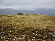
Summit cairn and Bronze Age at the summit

Small, disused quarry at the base of Great Mell Fell

A boulder in the bed of Routing Gill Beck on Great Mell Fell


References
- ↑ 1.0 1.1 Diana Whaley (2006). A Dictionary of Lake District Place-Names. Nottingham: English Place-Name Society. ISBN 0-904889-72-6.
- ↑ 2.0 2.1 2.2 2.3 2.4 2.5 2.6 2.7 Mark Richards (2008) [2003]. Near Eastern Fells. Milnthorpe: Cicerone Press. ISBN 978-1-852845414.
- ↑ Bill Birkett (1994). Complete Lakeland Fells. London: HarperCollins. ISBN 0583-32209-3.
- ↑ Harriet Martineau (1855) Complete Guide to the English Lakes, London, p 104. - available online at "Old Cumbria Gazetteer". http://www.geog.port.ac.uk/webmap/thelakes/html/lgaz/lgazfram.htm. Retrieved 17 March 2014.
- ↑ 5.0 5.1 5.2 Wainwright, Alfred: A Pictorial Guide to the Lakeland Fells, Book One — The Eastern Fells (1955)
- ↑ P. Stone (2010). British Regional Geology: Northern England. Nottingham: British Geological Society. ISBN 978-0852726525.
- ↑ British Geological Survey: Sheet E030, Appleby (Solid) 1:50,000 Geological Map (2004) ISBN 0751833886: Geology of Britain viewer
- ↑ "The BGS Lexicon of Named Rock Units". http://www.bgs.ac.uk/lexicon/.