Garton
- Not to be confused with Garton on the Wolds
| Garton | |
| Yorkshire East Riding | |
|---|---|
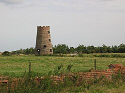
 Old Mill at Garton | |
| Location | |
| Grid reference: | TA264354 |
| Location: | 53°47’60"N, 0°4’53"W |
| Data | |
| Post town: | Hull |
| Postcode: | HU11 |
| Dialling code: | 01964 |
| Local Government | |
| Council: | East Riding of Yorkshire |
| Parliamentary constituency: |
Beverley and Holderness |
Garton (or Garton in Holderness) is a village in the East Riding of Yorkshire, a mile indland of the North Sea coast of the broad Holderness peninsula. The village is to be found seven miles north-west of Withernsea town centre, on the B1242 road.
The parish church, St Michael, is a Grade I listed building.[1]
History
In 1823 the village was noted as having 160 inhabitants. Occupations included ten farmers, a bricklayer, a carpenter and a blacksmith. Two carriers operated between the village and Hull on Tuesdays.[2]
During the Second World War, a German, moored, magnetic influence mine, TMA-1 came ashore at Corton sands at Garton. Lcdr. Roy Berryman Edwards, RN, DSO, BEM took the assignment to dismantle the mine, with an American Navy Mine Disposalman John Martin Howard observing the operation. The mine detonated during the disposal operation with the full four hundred and seventy pounds of charge. The detonation killed Howard and Edwards and scatted debris for two hundred yards in each direction along the beach.[3]
Outside links
| ("Wikimedia Commons" has material about Garton) |
- Garton in the Domesday Book
References
- ↑ National Heritage List 1215863: Church of St Michael (Grade I listing)
- ↑ Baines, Edward: 'History, Directory and Gazetteer of the County of York' (1823); page 209
- ↑ Bartleson, John D., Jr. (1995), History of U.S. Navy Mine Disposal, Washington, DC: United States Navy Explosive Ordnance Disposal Association, pp. 46–49, https://www.scribd.com/doc/68400349/MD-History-Scanned-PDF#
- Gazetteer – A–Z of Towns Villages and Hamlets. East Riding of Yorkshire Council. 2006. p. 6.