Braunton
| Braunton | |
| Devon | |
|---|---|
,_St_Brannock%27s_Church_--_2013_--_1557.jpg) St Brannock's Church | |
| Location | |
| Grid reference: | SS487365 |
| Location: | 51°6’31"N, 4°9’41"W |
| Data | |
| Population: | 7,353 (2011) |
| Post town: | Braunton |
| Postcode: | EX33 |
| Dialling code: | 01271 |
| Local Government | |
| Council: | North Devon |
Braunton is a large village in northern Devon, five west of Barnstaple. It is amongst the most populous of Devon's countless villages, with a population at the 2011 census of 7,353 people.
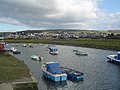
Within the parish is the fertile, low-lying Braunton Great Field, which adjoins the undulating Braunton Burrows; the largest sand dune system in Britain. It is on the coast of the Atlantic Ocean at the west of the parish at the large beach of Saunton Sands, one of the West Country's international-standard surfing beaches.
The town has a few hotels and guesthouses but numerous shops and pubs.
Contents
Name
The name 'Braunton' is derived from the two Old English elements: brom tun, meaning 'broom (shrub) farmstead'. The name is recorded in the Domesday Book of 1086 as Brantone.[1]

About the village
The South West Coast Path National Trail passes through the village and gives access for walkers to Devon's spectacular north coast. The Tarka Trail also passes through the village. Braunton Burrows marsh on the west side of the parish is a designated biosphere reserve, the first place in Great Britain to have gained such status.[2]
The coastal part of the parish lies within the North Devon Coast Area of Outstanding Natural Beauty, and comprises Saunton Sands to the west, a beach of finely-grained sand, and to the south the estuary of the River Taw, of mixed mud and sand. The north of Braunton Burrows are open to light public access and have been converted into a golf course.
Braunton was half-surrounded by an extensive brackish salt-water marsh restricting available agricultural land. In 1808 this was surveyed by Charles Vancouver, for the Board of Agriculture, who recommended that the marsh should be enclosed and reclaimed. This met with local approval and James Green was appointed as engineer for the drainage scheme. An Act of Parliament was obtained for the purpose on 25 May 1811. On completion, responsibility for the marsh passed Marsh Inspectors, who sanctioned further work in 1854, involving the straightening and embanking of the River Caen, or Braunton Pill, to form the Braunton Canal. The scheme was completed by the addition of a new quay at Velator in the 1870s.
To the west of Braunton is Saunton and its beach and the sand dune system but bordering the village is what is reputed to be the largest remaining 'strip' farming area in the United Kingdom, and which known as the 'Great Field' . Probably from mediæval times and continuing today, this large area has been opened tilled without formal boundaries, with at least three families still involved in production. This boundary effect by the 'Great Field' now acts as a 'natural' barrier to the development of the village in that direction.
During building works in the end of the 20th century, two strange findings revealed something of the areas geology. In one area of the village high on the side of the hill and about 100 feet above the flat area of the village, excavations for foundations of a house three feet dug deep broke in to a pocket of sand and which was found to extend greater than 16 feet. The subsequent house had to be built on a raft on the sand. Research by the Univerity of Exeter concluded that it was a beach pushed up by a glacier during the last ice age. At similar time in the flat area of the village, excavations for foundations revealed large rounded and smooth stones which were put down the wide water course having been present at some time rather than the small river that flows through the village now.
Braunton railway station formerly existed on the now closed Ilfracombe Branch Line two stations from Barnstaple railway station on the 'Tarka' or North Devon Line from Exeter, which currently operate regular and heritage trains.
The presence of the river, the 'soft' water and permission for abstraction, encouraged an American company, 'Curity' to set up business in the village in the early 60's for the purposes of bleaching and processing imported raw cotton wool from the United State into various products such as cotton wool balls, and rolls of perfectly white cotton for other companies to make such products as tampons and other medical/surgical products. Despite being in operation for about 40 years, the softness of the water and minimal [resin] 'ion exchange' meant that the 'Steambloc' boilers needed no treatment or aggressive cleaning.
Parish church
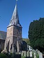
The parish church is St Brannock's, now a Grade-I listed building[3] It is dedicated to St Brannock or Brynach.
This is a large edicfice with a Norman tower topped by a spire.[4] A fine series of richly carved 16th-century bench-ends survive with other interesting carved woodwork.
The building is almost entirely 15th-century, excepting the 13th-century chancel with its arch and three lancet windows. The advowson of the parish church was historically a possession of Exeter Cathedral.
Monuments and furnishings
In the floor of the choir is an unusual monumental brass which is a palimpsest. It depicts on its uppermost side Elizabeth Bourchier (d.1548), a daughter of John Bourchier, 1st Earl of Bath of Tawstock Court, feudal baron of Bampton, Devon, and the wife of Edward Chichester (d.1522) of Raleigh[5] in the nearby parish of Pilton, Devon|Pilton. Her husband inherited the estate of Saunton, in the parish of Braunton, from his mother Margaret Beaumont,[6] daughter and heiress of Hugh Beaumont of Shirwell, and her 3rd son Philip Chichester was seated at Saunton,[7] where his mother may have spent her widowhood. Alternatively she may have lived at Ash, in the parish of Braunton, which in the 16th century the Bourchiers purchased from the Bellew family,[8] whilst the Bourchiers also owned the estate of Beare in the parish of Braunton.[9] A 16th-century wooden chest survives, with engravings of Portuguese men who may have come to England with the Spanish Armada of 1588.
Events
The village holds a carnival each year near the end of May.
Surfing
Since the closing years of the 20th century, the village has become a hub for surfing as it is on the main road gateway to three of the West Country's surf beaches of Saunton, Croyde and Putsborough, all with fine powdery sand, and to a lesser extent a road to Woolacombe). The Museum of British Surfing opened in 2012 in the old goods shed of the old Braunton Railway Station on the Ilfracombe Branch Line.[10][11]
A number of major surf brands are associated with the village including Tiki and Salt Rock.
Pictures

Braunton Burrows in Devon

Braunton Burrows

Braunton Marshes
Velator Quay

A reminder of Braunton's railway: rails left in the road
Braunton and the Great Field beyond

St. Michael's Chapel Ruin
St Brannock's Church

Station House of the old Railway Station

Braunton & District Museum

Memorial Garden

,_Braunton_Burrows_--_2013_--_1837.jpg)


,_Old_Railway_Station,_Station_House_--_2013_--_00190.jpg)
,_Braunton_%26_District_Museum_--_2013_--_00191.jpg)
,_Memorial_Garden_--_2013_--_00229.jpg)
Outside links
| ("Wikimedia Commons" has material about Braunton) |
- The Explore Braunton Project
- Tourist Information Centre
- Christ Church
- Information on Braunton from GENUKI
References
- ↑ Thorn & Thorn, part 1, 1,5
- ↑ bbc.co.uk Devon/Outdoors/Nature. Retrieved 13 July 2013
- ↑ National Heritage List 1325560: St Brannock's Chuch, Braunton
- ↑ St Brannock's church website – includes history page
- ↑ Vivian, p.107; per inscription on brass
- ↑ Lysons, Daniel and Lysons, Samuel: Magna Britannia, Vol.6, 'Devonshire' (1822)
- ↑ Vivian, p.173, pedigree of Chichester
- ↑ Pole, Sir William (d.1635), Collections Towards a Description of the County of Devon, Sir John-William de la Pole (ed.), London, 1791, p.396
- ↑ Risdon, p.338
- ↑ "The Museum Story". Museum of British Surfing. http://www.museumofbritishsurfing.org.uk/about/. Retrieved 13 August 2016.
- ↑ Booth, Robert (24 August 2012). "Wave hello: the birth of British surfing". Guardian. https://www.theguardian.com/sport/2012/aug/24/surfing-anniversary-cornwall-devon. Retrieved 13 August 2016.