Bentinck
From Wikishire
| Bentinck | |
| Derbyshire | |
|---|---|
 Bentinck | |
| Location | |
| Grid reference: | SK466734 |
| Location: | 53°15’22"N, 1°18’7"W |
| Data | |
| Post town: | Chesterfield |
| Postcode: | S44 |
| Dialling code: | 01246 |
| Local Government | |
| Council: | Bolsover |
| Parliamentary constituency: |
Bolsover |
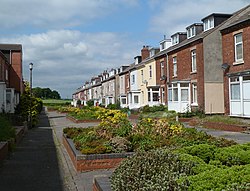
Bentinck is a hamlet in Derbyshire to the north of Bolsover. It consists of two rows of terrace houses, a park and some garages.
Bentinck is immediately north of Shuttlewood, on a lane leading off Woodthorpe Road to Mastin Moor. It is located near two motorway junctions of the M1, J29a and J30. It is also close to Chesterfield and the city of Sheffield. The main employer of the village up until a few years ago was Coalite, and before that the mining industry.
The hamlet was built in the 19th century to house the local miners from the colliery at Shuttlewood. There was a road which is now abandoned linking the village to the mine.