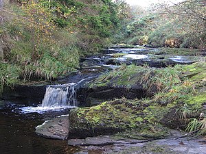
Bells Linn
From Wikishire
| Bells Burn | |
| Northumberland, Roxburghshire | |
|---|---|
 Bells Linn | |
| River: | Bells Burn |
| NY612949 | |
| Co-ordinates: | 55°14’49"N, 2°36’42"W |
Bells Linn is a tiny waterfall in the Kielder Forest at the edge of the Cheviots. It is on the Bells Burn, a small stream and a tributary of the Kielder Burn, which here marks the border of Northumberland to the south-east and Roxburghshire to the north-west. The fall is just a few hundred yards upstream of the point where the Bells Burn enters the Kielder Burn, the main headwater of the River North Tyne.
It is at this waterfall that the county border turns and heads north-westwards and over the fells. The Kielder Forest extends south of the falls.
Just upstream of Bells Linn is Spout Linn, and half a mile further upstream is Anthon’s Linn; Linn being an Old English word for a torrent or waterfall.
Outside links
| ("Wikimedia Commons" has material about Bells Burn) |