File:William Smith Memorial, Barnoldby le Beck - geograph.org.uk - 873333.jpg
From Wikishire

Size of this preview: 469 × 599 pixels. Other resolution: 188 × 240 pixels.
Original file (501 × 640 pixels, file size: 152 KB, MIME type: image/jpeg)
Summary
| Description |
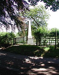
English: William Smith Memorial, Barnoldby le Beck Obelisk on the east side of the lane between St Helen's Church and The Old Rectory at Barnoldby le Beck. The memorial was erected on the spot where William Smith, huntsman to the Earl of Yarborough, fell from his horse and suffered head injuries on 11th April 1845. Smith died five days later at the home of a friend. |
| Date | |
| Source | From geograph.org.uk |
| Author | Paul Glazzard |
| Attribution (required by the license) | Paul Glazzard / William Smith Memorial, Barnoldby le Beck / |
| Camera location | | View this and other nearby images on: OpenStreetMap |
|---|
_heading:67.00&language=en)
| Object location | | View this and other nearby images on: OpenStreetMap |
|---|
_heading:67.00&language=en)
Licensing

|
This image was taken from the Geograph project collection. See this photograph's page on the Geograph website for the photographer's contact details. The copyright on this image is owned by Paul Glazzard and is licensed for reuse under the Creative Commons Attribution-ShareAlike 2.0 license.
|
This file is licensed under the Creative Commons Attribution-Share Alike 2.0 Generic license.
Attribution: Paul Glazzard
- You are free:
- to share – to copy, distribute and transmit the work
- to remix – to adapt the work
- Under the following conditions:
- attribution – You must give appropriate credit, provide a link to the license, and indicate if changes were made. You may do so in any reasonable manner, but not in any way that suggests the licensor endorses you or your use.
- share alike – If you remix, transform, or build upon the material, you must distribute your contributions under the same or compatible license as the original.
File history
Click on a date/time to view the file as it appeared at that time.
| Date/Time | Thumbnail | Dimensions | User | Comment | |
|---|---|---|---|---|---|
| current | 10:46, 21 February 2011 | | 501 × 640 (152 KB) | GeographBot | == {{int:filedesc}} == {{Information |description={{en|1=William Smith Memorial, Barnoldby le Beck Obelisk on the east side of the lane between St Helen's Church and The Old Rectory at Barnoldby le Beck. The memorial was erected on the spot where William |
File usage
The following file is a duplicate of this file (more details):
- File:William Smith Memorial, Barnoldby le Beck - geograph.org.uk - 873333.jpg from a shared repository
The following page links to this file: