File:Wicklow Way Marker Curtlestown.jpg
From Wikishire

Size of this preview: 800 × 450 pixels. Other resolution: 320 × 180 pixels.
Original file (3,644 × 2,050 pixels, file size: 3.1 MB, MIME type: image/jpeg)
Summary
| Description |
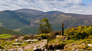
English: A waymarker on the Wicklow Way National Waymarked Trail near Curtlestown Wood, County Wicklow Ireland overlooking the Glencree valley with the mountains Maulin, Djouce and War Hill in the distance. |
| Date | |
| Source | Own work |
| Author | Joe King |
| Permission (Reusing this file) |
This image is licenced under the Creative Commons Attribution-ShareAlike 3.0 Unported. You are free to create, remix, and make derivative works based on the photo, as long as you distribute the derivative work under this ShareAlike Creative Commons license. You must give credit to the owner of the photo. |
| Camera location | | View this and other nearby images on: OpenStreetMap |
|---|
Licensing
I, the copyright holder of this work, hereby publish it under the following license:
This file is licensed under the Creative Commons Attribution-Share Alike 3.0 Unported license.
- You are free:
- to share – to copy, distribute and transmit the work
- to remix – to adapt the work
- Under the following conditions:
- attribution – You must give appropriate credit, provide a link to the license, and indicate if changes were made. You may do so in any reasonable manner, but not in any way that suggests the licensor endorses you or your use.
- share alike – If you remix, transform, or build upon the material, you must distribute your contributions under the same or compatible license as the original.
| Annotations | This image is annotated: View the annotations at Commons |
File history
Click on a date/time to view the file as it appeared at that time.
| Date/Time | Thumbnail | Dimensions | User | Comment | |
|---|---|---|---|---|---|
| current | 16:12, 11 May 2011 | | 3,644 × 2,050 (3.1 MB) | Joe King | {{Information |Description ={{en|1=A waymarker on the Wicklow Way National Waymarked Trail near Curtlestown Wood, County Wicklow Ireland overlooking the Glencree valley with the mountains Maulin, Djouce and War Hill in the distance.}} |Source = |
File usage
The following file is a duplicate of this file (more details):
- File:Wicklow Way Marker Curtlestown.jpg from a shared repository
The following page links to this file: