File:Welwick Saltmarsh Nature Reserve (geograph 5562249).jpg

.jpg)
Summary
| Description |
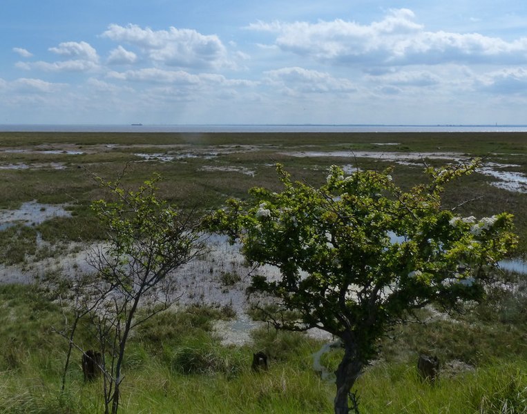
English: Welwick Saltmarsh Nature Reserve, Welwick, East Riding of Yorkshire, England. Welwick Saltmarsh is the most extensive area of saltmarsh on the north bank of the River Humber. Humber Estuary
|
| Date | |
| Source | From geograph.org.uk |
| Author | Mat Fascione |
| Permission (Reusing this file) |
Creative Commons Attribution Share-alike license 2.0 |
| Attribution (required by the license) | Mat Fascione / Welwick Saltmarsh Nature Reserve / |
| Camera location | | View this and other nearby images on: OpenStreetMap |
|---|
.jpg¶ms=053.649468_N_0000.035083_E_globe:Earth_type:camera_source:geograph-osgb36(TA34611892)_heading:202.00&language=en)
| Object location | | View this and other nearby images on: OpenStreetMap |
|---|
.jpg¶ms=053.649470_N_0000.035080_E_globe:Earth_class:object_type:object_source:geograph-osgb36(TA34611892)_heading:202.00&language=en)
Licensing

|
This image was taken from the Geograph project collection. See this photograph's page on the Geograph website for the photographer's contact details. The copyright on this image is owned by Mat Fascione and is licensed for reuse under the Creative Commons Attribution-ShareAlike 2.0 license.
|
- You are free:
- to share – to copy, distribute and transmit the work
- to remix – to adapt the work
- Under the following conditions:
- attribution – You must give appropriate credit, provide a link to the license, and indicate if changes were made. You may do so in any reasonable manner, but not in any way that suggests the licensor endorses you or your use.
- share alike – If you remix, transform, or build upon the material, you must distribute your contributions under the same or compatible license as the original.
File history
Click on a date/time to view the file as it appeared at that time.
| Date/Time | Thumbnail | Dimensions | User | Comment | |
|---|---|---|---|---|---|
| current | 17:07, 3 February 2022 | | 800 × 629 (144 KB) | Keith D | == {{int:filedesc}} == {{Information |Description={{en|1=Welwick Saltmarsh Nature Reserve, Welwick, East Riding of Yorkshire, England.<br />Welwick Saltmarsh is the most extensive area of saltmarsh on the north bank of the River Humber.<br /> [https://www.geograph.org.uk/snippet/13506 Humber Estuary] <br /> The Humber is a large tidal estuary on the east coast of Northern England. It is formed at Trent Falls, Faxfleet, by the confluence of the... |
File usage
The following file is a duplicate of this file (more details):
.jpg)
- File:Welwick Saltmarsh Nature Reserve (geograph 5562249).jpg from a shared repository
The following page links to this file:
.jpg)
.jpg)
.jpg&action=edit&redlink=1)
.jpg)
.jpg&printable=yes)
.jpg&action=info)