File:Wappenshall Junction, Shrewsbury Canal - geograph.org.uk - 335323.jpg
From Wikishire
No higher resolution available.
Wappenshall_Junction,_Shrewsbury_Canal_-_geograph.org.uk_-_335323.jpg (640 × 465 pixels, file size: 105 KB, MIME type: image/jpeg)
Summary
| Description |
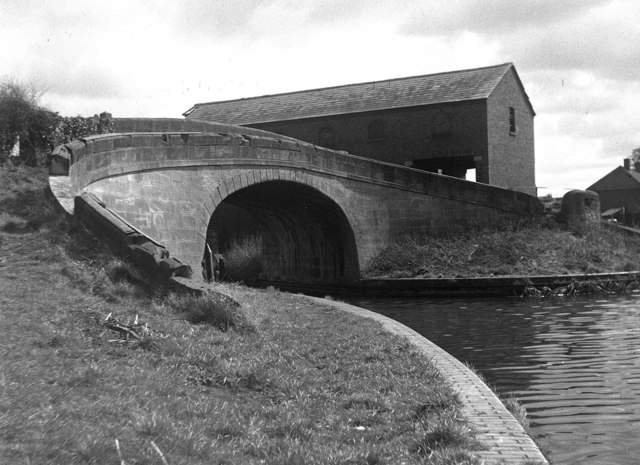
English: Wappenshall Junction, Shrewsbury Canal This photograph, taken in 1964, shows the canal junction at which the Shrewsbury and Newport Canal, coming in from the right, joined the earlier Shrewsbury Canal, from left to forward. Remarkably the handsome warehouse building, as well as the bridge, survives in 2007. A trust exists whose object is the restoration of these canals. |
| Date | |
| Source | From geograph.org.uk |
| Author | Dr Neil Clifton |
| Attribution (required by the license) | Dr Neil Clifton / Wappenshall Junction, Shrewsbury Canal / |
| Camera location | | View this and other nearby images on: OpenStreetMap |
|---|
_heading:315.00&language=en)
| Object location | | View this and other nearby images on: OpenStreetMap |
|---|
_heading:315.00&language=en)
Licensing

|
This image was taken from the Geograph project collection. See this photograph's page on the Geograph website for the photographer's contact details. The copyright on this image is owned by Dr Neil Clifton and is licensed for reuse under the Creative Commons Attribution-ShareAlike 2.0 license.
|
This file is licensed under the Creative Commons Attribution-Share Alike 2.0 Generic license.
Attribution: Dr Neil Clifton
- You are free:
- to share – to copy, distribute and transmit the work
- to remix – to adapt the work
- Under the following conditions:
- attribution – You must give appropriate credit, provide a link to the license, and indicate if changes were made. You may do so in any reasonable manner, but not in any way that suggests the licensor endorses you or your use.
- share alike – If you remix, transform, or build upon the material, you must distribute your contributions under the same or compatible license as the original.
File history
Click on a date/time to view the file as it appeared at that time.
| Date/Time | Thumbnail | Dimensions | User | Comment | |
|---|---|---|---|---|---|
| current | 22:53, 30 December 2010 | | 640 × 465 (105 KB) | GeographBot | == {{int:filedesc}} == {{Information |description={{en|1=Wappenshall Junction, Shrewsbury Canal This photograph, taken in 1964, shows the canal junction at which the Shrewsbury and Newport Canal, coming in from the right, joined the earlier Shrewsbury Can |
File usage
The following file is a duplicate of this file (more details):
- File:Wappenshall Junction, Shrewsbury Canal - geograph.org.uk - 335323.jpg from a shared repository
The following page links to this file: