File:View towards Corehead with Great Hill and Chalk Rig Edge beyond.jpg
From Wikishire

Size of this preview: 800 × 372 pixels. Other resolution: 320 × 149 pixels.
Original file (900 × 419 pixels, file size: 78 KB, MIME type: image/jpeg)
Summary
| Description |
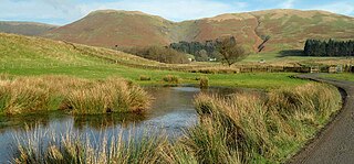
English: The Annandale Way is a 53-mile (85 km) hiking trail in Scotland. View towards Corehead with Great Hill (left of centre) and Chalk Rig Edge (right of centre) beyond.
Scothill Own Work 11th November 2011 |
| Date | 21 February 2012 (original upload date) |
| Source |
Own work Transferred from en.wikipedia |
| Author | Scothill at en.wikipedia |
Licensing
Scothill at en.wikipedia, the copyright holder of this work, hereby publishes it under the following license:
This file is licensed under the Creative Commons Attribution-Share Alike 3.0 Unported license.
Attribution: Scothill at en.wikipedia
- You are free:
- to share – to copy, distribute and transmit the work
- to remix – to adapt the work
- Under the following conditions:
- attribution – You must give appropriate credit, provide a link to the license, and indicate if changes were made. You may do so in any reasonable manner, but not in any way that suggests the licensor endorses you or your use.
- share alike – If you remix, transform, or build upon the material, you must distribute your contributions under the same or compatible license as the original.
Original upload log
The original description page was here. All following user names refer to en.wikipedia.
- 2012-02-21 18:13 Scothill 900×419 (79391 bytes) Scothill Own Work 11th November 2011
File history
Click on a date/time to view the file as it appeared at that time.
| Date/Time | Thumbnail | Dimensions | User | Comment | |
|---|---|---|---|---|---|
| current | 19:41, 24 February 2012 | | 900 × 419 (78 KB) | MGA73bot2 | == {{int:filedesc}} == {{Information |description={{en|1=The Annandale Way is a 53-mile (85 km) hiking trail in Scotland. View towards Corehead with Great Hill (left of centre) and Chalk Rig E... |
File usage
The following file is a duplicate of this file (more details):
- File:View towards Corehead with Great Hill and Chalk Rig Edge beyond.jpg from a shared repository
The following page links to this file: