File:Thorpe St Andrew Church - geograph.org.uk - 171329.jpg
From Wikishire

Size of this preview: 450 × 600 pixels. Other resolution: 180 × 240 pixels.
Original file (480 × 640 pixels, file size: 88 KB, MIME type: image/jpeg)
Summary
| Description |
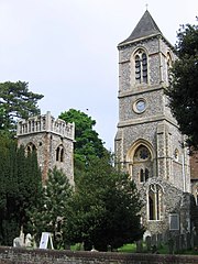
English: Church towers at Thorpe St Andrew, Norfolk. On the left is the 15th-century tower of the ruined former parish church. On the right is the Gothic revival tower added to the new parish church in 1882. |
| Date | |
| Source | From geograph.org.uk; transferred by User:oxyman using geograph_org2commons. |
| Author | Graham Hardy |
| Permission (Reusing this file) |
Creative Commons Attribution Share-alike license 2.0 |
| Attribution (required by the license) | Graham Hardy / Thorpe St Andrew Church / |
| Camera location | | View this and other nearby images on: OpenStreetMap |
|---|
| Object location | | View this and other nearby images on: OpenStreetMap |
|---|
_region:GB-GBN_heading:337.00&language=en)
Licensing

|
This image was taken from the Geograph project collection. See this photograph's page on the Geograph website for the photographer's contact details. The copyright on this image is owned by Graham Hardy and is licensed for reuse under the Creative Commons Attribution-ShareAlike 2.0 license.
|
This file is licensed under the Creative Commons Attribution-Share Alike 2.0 Generic license.
Attribution: Graham Hardy
- You are free:
- to share – to copy, distribute and transmit the work
- to remix – to adapt the work
- Under the following conditions:
- attribution – You must give appropriate credit, provide a link to the license, and indicate if changes were made. You may do so in any reasonable manner, but not in any way that suggests the licensor endorses you or your use.
- share alike – If you remix, transform, or build upon the material, you must distribute your contributions under the same or compatible license as the original.
File history
Click on a date/time to view the file as it appeared at that time.
| Date/Time | Thumbnail | Dimensions | User | Comment | |
|---|---|---|---|---|---|
| current | 03:24, 25 October 2009 | | 480 × 640 (88 KB) | File Upload Bot (Magnus Manske) | == Summary == {{Information |Description=Thorpe St Andrew Church |Source=From [http://www.geograph.org.uk/photo/171329 geograph.org.uk]; transferd by User:oxyman using [http://toolserver.org/~magnus/geograph_org2commons.php geograph_org2commons]. |Dat |
File usage
The following file is a duplicate of this file (more details):
- File:Thorpe St Andrew Church - geograph.org.uk - 171329.jpg from a shared repository
The following page links to this file: