File:The end of the Chet - geograph.org.uk - 1687469.jpg
From Wikishire
No higher resolution available.
The_end_of_the_Chet_-_geograph.org.uk_-_1687469.jpg (800 × 531 pixels, file size: 121 KB, MIME type: image/jpeg)
Summary
| Description |
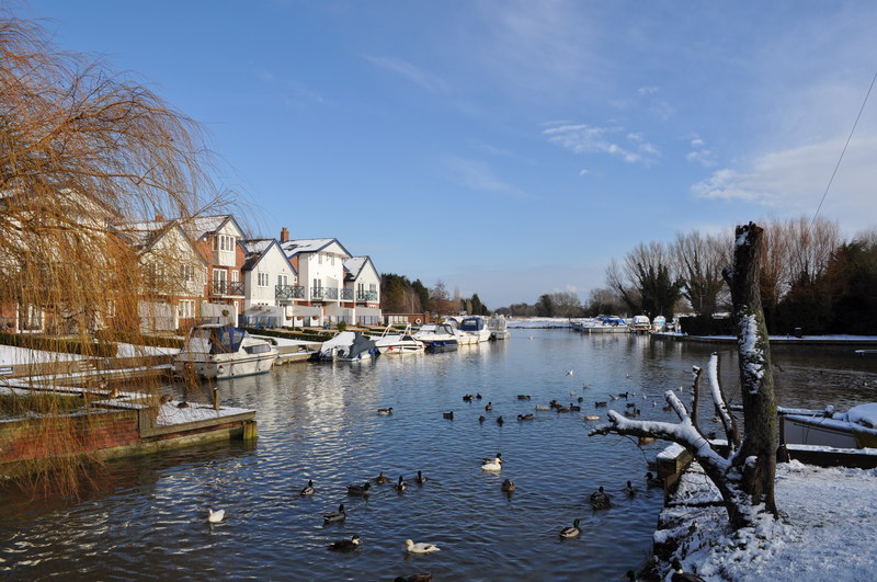
English: The end of the Chet, near to Loddon, Norfolk, Great Britain.
This is the end of the navigational Chet at Loddon moorings. The Moorings on the right are free for 24 hours and on the left are private. The houses are built on the site of boat yards, when I was at first school in the nineties I remember them when feeding the ducks. When the boat trade moved else where luxury houses where built, transforming the view (For better or worse is debatable). |
| Date | |
| Source | From geograph.org.uk; transferred by User:Rubberstamp using geograph_org2commons. |
| Author | Ashley Dace |
| Permission (Reusing this file) |
Creative Commons Attribution Share-alike license 2.0 |
| Camera location | | View this and other nearby images on: OpenStreetMap |
|---|
| Object location | | View this and other nearby images on: OpenStreetMap |
|---|
_region:GB-GBN_heading:67.00&language=en)
Licensing

|
This image was taken from the Geograph project collection. See this photograph's page on the Geograph website for the photographer's contact details. The copyright on this image is owned by Ashley Dace and is licensed for reuse under the Creative Commons Attribution-ShareAlike 2.0 license.
|
This file is licensed under the Creative Commons Attribution-Share Alike 2.0 Generic license.
Attribution: Ashley Dace
- You are free:
- to share – to copy, distribute and transmit the work
- to remix – to adapt the work
- Under the following conditions:
- attribution – You must give appropriate credit, provide a link to the license, and indicate if changes were made. You may do so in any reasonable manner, but not in any way that suggests the licensor endorses you or your use.
- share alike – If you remix, transform, or build upon the material, you must distribute your contributions under the same or compatible license as the original.
File history
Click on a date/time to view the file as it appeared at that time.
| Date/Time | Thumbnail | Dimensions | User | Comment | |
|---|---|---|---|---|---|
| current | 15:14, 24 July 2010 | | 800 × 531 (121 KB) | File Upload Bot (Magnus Manske) | == {{int:filedesc}} == {{Information |Description={{en|1=The end of the Chet, near to Loddon, Norfolk, Great Britain. This is the end of the navigational Chet at Loddon moorings. The Moorings on the right are free for 24 hours and on the left are private. |
File usage
The following file is a duplicate of this file (more details):
- File:The end of the Chet - geograph.org.uk - 1687469.jpg from a shared repository
The following 2 pages link to this file: