File:The disused racecourse on the Hergest Ridge - geograph.org.uk - 1444713.jpg
From Wikishire
No higher resolution available.
The_disused_racecourse_on_the_Hergest_Ridge_-_geograph.org.uk_-_1444713.jpg (640 × 421 pixels, file size: 84 KB, MIME type: image/jpeg)
Summary
| Description |
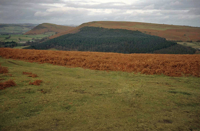
English: The disused racecourse on the Hergest Ridge. From the hilltop looking north-east to the partially wooded Bradnor Hill, with Herrock Hill beyond to the left. This track is part of the oval-shaped Kington Racecourse on the Hergest Ridge, which is still clearly marked on the OS map. The racecourse started up in 1825 and held regular events until around 1880. It replaced an original course running around the top of Bradnor Hill, which began use in about 1770.
See also 1727616. |
| Date | |
| Source | From geograph.org.uk |
| Author | Trevor Rickard |
| Attribution (required by the license) | Trevor Rickard / The disused racecourse on the Hergest Ridge / |
| Camera location | | View this and other nearby images on: OpenStreetMap |
|---|
_heading:45.00&language=en)
| Object location | | View this and other nearby images on: OpenStreetMap |
|---|
_heading:45.00&language=en)
Licensing

|
This image was taken from the Geograph project collection. See this photograph's page on the Geograph website for the photographer's contact details. The copyright on this image is owned by Trevor Rickard and is licensed for reuse under the Creative Commons Attribution-ShareAlike 2.0 license.
|
This file is licensed under the Creative Commons Attribution-Share Alike 2.0 Generic license.
Attribution: Trevor Rickard
- You are free:
- to share – to copy, distribute and transmit the work
- to remix – to adapt the work
- Under the following conditions:
- attribution – You must give appropriate credit, provide a link to the license, and indicate if changes were made. You may do so in any reasonable manner, but not in any way that suggests the licensor endorses you or your use.
- share alike – If you remix, transform, or build upon the material, you must distribute your contributions under the same or compatible license as the original.
File history
Click on a date/time to view the file as it appeared at that time.
| Date/Time | Thumbnail | Dimensions | User | Comment | |
|---|---|---|---|---|---|
| current | 03:23, 2 March 2011 | | 640 × 421 (84 KB) | GeographBot | == {{int:filedesc}} == {{Information |description={{en|1=The disused racecourse on the Hergest Ridge From the hilltop looking north-east to the partially wooded Bradnor Hill, with Herrock Hill beyond to the left. This track is part of the oval-shaped King |
File usage
The following file is a duplicate of this file (more details):
- File:The disused racecourse on the Hergest Ridge - geograph.org.uk - 1444713.jpg from a shared repository
The following page links to this file: